
After spending a pleasant hour or so at Reykjavik's National Museum of Iceland, Steven and I made a mad dash to the ferry dock next to the cruise ship terminal to catch the ferry to Viðey Island, located a few hundred yards offshore. Lady Luck was with us, as if we'd been a minute later, we'd have missed the ferry.
Viðey is the largest island in Kollafjörður Bay and would be a relaxing escape from the crowds in the capital after two particularly hectic days, even if they were of our own choosing!
Viðey is a historically significant site with traces of human habitation dating back to the 10th century. An Augustine monastery was founded on the island in 1225, and it became an influential center of learning and culture until it was shuttered during the Reformation in the 16th century. During the early to mid-20th century, the island was home to a bustling port that was almost as important as Reykjavik's, but the last of the island's inhabitants left in 1943 when a fisheries company closed down.


Above the island's dock was Viðey House, the oldest stone building in the country. It was built in 1752 at the expense of the Danish king as the official residence of Skúli Magnússon, the first Icelander to serve as the country's Treasurer. It was designed in the Rococo style by Nicolai Eigtved, one of Denmark's most renowned architects, whose work also includes Amalienborg Palace in Copenhagen. Though it may appear simple to us, to Icelanders who had only known turf buildings, it was known as the "palace on Viðey."
When Magnússon commissioned plans for a new stone church in 1767, and it was consecrated in 1774, the adjacent Viðey Church became the second-oldest church in Iceland, after Hólar Cathedral, which was built in 1763. It was designed and constructed to harmonize with Viðey House, utilizing the same Icelandic stone and lime mortar, the same style of roof, the same-sized windows, and consistent proportions. The church's interior fittings are the oldest in Iceland.


A view looking to the mainland:

Flower lovers would have a field day on Viðey Island with common yarrow, northern bedstraw, and sorrel growing in abundance. The Plants of Viðey pamphlet I'd picked up on the boat made it fun to be on the lookout for the island's flowers.

We traipsed through the grass to the western part of the island to view the Imagine Peace Tower, dedicated in 2007 by Yoko Ono, the widow of John Lennon, as a beacon for world peace. Between his birthday on October 9th and December 8th, the day of his death, a tall tower of light (a beacon) emerges from the center of the well. The words 'Imagine Peace' were inscribed in 24 languages in Lennon's memory.

If we were here when the light is shining, I could 'imagine' being quite impressed with Ono's vision. However, the site, as we saw it, left us underwhelmed.

We didn't realize it at the time, but garden angelica was also one of the most commonly found plants throughout Iceland.

Atop a small hill lay an anchor believed to belong to the cutter Ingvar that ran aground in a violent storm on a reef off the shore of Viðey Island in April of 1906. The crew of twenty perished when the boat was battered to pieces by the gale and waves.
It's been decades since either of us had trampled on paths like these! Reykjavik did indeed seem a world away, not just a 10-minute boat ride.
Tufted vetch:
Creeping thyme:

Wood cranesbills dotted the hillside in every direction.


Being on a 'real' path again was welcome as we took in the view of West Island across the isthmus from where we'd landed on Home Island. We hadn't realized that Viðey Island comprised both West and Home Islands before we arrived on it.


Standing Stones was an art installation of nine pairs of basalt pillars set up on West Island in 1990 by American artist Richard Serra, who had been commissioned by the Reykjavik Art Museum. The basalt columns were a reference to Viðey's geology. All the pillars could be viewed from the highest point on West Viðey, at 18 meters above sea level.


We, or at least I, had hoped to view several sets of Serra's pillars, but trying to navigate a 'path' through six-inch tall, only somewhat trampled grass and unknown hazards wasn't much fun. It felt like one of us was one foot away from a severely sprained or broken ankle. That was why we were content with just seeing this third set of pillars.

Red sorrel was new to us. To the right of the plant was what was euphemistically referred to as the path. Ha!

Views of the Big Pond on West Island's southeast tip:

Atop a hill near the church and stone house was the island's former caretaker's turf house, built 30 years ago, and the first image that anyone sees when approaching the island. The current caretaker resides on the mainland and commutes to work each day by ferry. What a stress-free way to get to work!
We then explored part of the Home Island, although it wasn't nearly as beautiful as West Island. Infinitely safer, yes, but less interesting in our minds. According to a travel brochure, Viðey is also said to be a haven for birdwatchers. However, we hadn't seen or heard many birds until we walked around Home Island.

At the end of the trail was the island's old schoolhouse, built in 1928. It was all that remained of the original village.

A protected bird nesting site:
These stones were possibly part of a stone wall erected by Magnússon around the island or part of the monastery; the signage on the island was poor, so we were unsure.
Viðey was a great escape, and as peaceful and pretty as it gets, but I hope I never walk on paths like some of those again! Our chariot, I mean, our boat, on approach from the mainland:
Back ashore on terra firma:
Sun Voyageur was an iconic landmark on Reykjavik's waterfront.

When Steven and I first visited Reykjavik in 2013, I don't remember being aware of any striking architecture. The city has indeed undergone a significant transformation in the intervening dozen years.


A couple of months ago, we'd made reservations for the highly rated Lava Show, as it promised a "fun and safe way" to see real flowing lava up close. The show was created by a local couple who were inspired by the 2010 eruption of Eyjafjallajökull and wanted to share the fascinating science of Iceland's volcanic activity with guests. As you likely remember, the volcanic ash from the 2010 eruption of Eyjafjallajökull caused the worst disruption in air travel since the September 11 attacks, with the massive ash plume rising about 12.4 miles into the atmosphere. Air traffic throughout Europe came to a standstill.

Our enthusiastic host was Ian (Iain?) from Lewis in Scotland's Outer Hebrides, who had married an Icelandic woman and had a seemingly credible Icelandic accent, if we were to judge at least. A former teacher for 21 years, he sounded like he'd found his niche playing with fire in Reykjavik! He explained that Eyjafjallajökull translates to Island Mountain Glacier and had 100-plus people in the auditorium trying to pronounce that mouthful.
Because Eyjafjallajökull was tough to pronounce, some newscasters referred to it as E15, i.e., the first letter and the remaining number of letters in its name! Some Icelanders joke that, however, it put their country "on the map" and sparked an unprecedented wave of tourism.
Ian introduced the 'fire master' who was responsible for heating up basalt from the 1918 eruption of the Katla volcano in southern Iceland, to 2000°F, resulting in molten lava!
Iceland's history with volcanoes: The country has more active volcanoes than anywhere else on Earth, with 30 active volcanic systems, 19 of which have erupted since the country's Settlement Age over 1,000 years ago. Iceland experiences significant volcanic activity because it sits atop a hotspot that continuously pushes magma toward the surface, and because the Mid-Atlantic Ridge cuts right through the island from north to south. It comprises two tectonic plates steadily moving away from each other, leaving cracks in the Earth's crust that allow magma to reach the surface more easily.
According to the Lava Show, there are only two natural phenomena that can result in a catastrophic extinction rate: a large meteor hitting the Earth, similar to what happened 65 million years ago, and a violent eruption of one of Earth's six so-called super volcanoes. Even though the Lava Show assured everyone we don't have to worry about the odds of a super volcano going off in our lifetime, and that some of the eruptions that have taken place in Iceland in recent years have been relatively small and seemingly innocent, Icelandic volcanoes can still be hazardous.
In 939, all hell broke loose in one of the most catastrophic eruptions in 'modern' history at the aptly named Eldgjá, as it translates to Fire Canyon, when the earth was ripped apart in a 47-mile-long fissure in southern Iceland. The eruption lasted for four years and produced the largest amount of lava in what is referred to as 'historic time,' covering more than 300 square miles of land. The Eldgjá eruption marked the end of an era when settlers came to Iceland.
Let the show begin: Everyone donned protective glasses, and Ian also wore a protective coat before molten lava began pouring down a narrow chute immediately in front of where Steven and I sat. We had arrived early, knowing that the best seats in the house were close to the action. Ian explained that the lava pouring down the chute was 2000°F or about 1100°C. Fortunately, most people had shed a couple of layers ahead of time, because it got hot in there in no time.
Almost immediately, Ian began showing how pliable the lava was, making glass fibers or Pele's Hair ...

... a few moments later, flipping the lava at the bottom of the chute over to show how scorching red it still was, joking it was still 'rare lava,' and not 'well done.'

Minutes later, he knew the lava temperature was still over 600°F, because it was still glowing. This whole time, there were nonstop popping and cracking sounds as some of the lava settled at the bottom of the chute.
Hint: If you visit, the Lava Show is hugely fun and educational, but I'd recommend not sitting in the front row as we did, as a speck of lava landed on my left hand, stinging it immediately, and later resulting in a very tiny scar two weeks later.

Ian showed us the lava's ropey texture and how 'easily' he was able to lift it up with a long pole. He mentioned that 47% of the lava was made up of mica, and the rate of the lava's cooling. He recommended touring lava tubes in Iceland that have formed when molten lava flows, the surface cools and solidifies, creating a crust while the molten lava continues to flow beneath. This creates a hollow tube within the lava flow. Eventually, the molten lava drains out, leaving behind a cave-like tunnel! Ian added that the temperatures in some tunnels were still 400°C two years later.
When Ian turned on the lights, he put a shield over the chute and showed us how the cooled lava had already transformed into what looked like hardened glass.

Thirty minutes after the initial lava poured down the chute, it was still dangerously hot. None of the lava was wasted from any of the shows, as after each performance, the 'fire master' collects the hardened lava and returns it to the furnace to be reheated to 2000°F for the next group to ooh and ahh over!
We grabbed a couple of burgers and dropped an eyewatering amount of money at Tommi's Burger Joint. At least they were good!
That night, we took a stroll on a magnificent path along Reykjavik's stunning Seltjarnarnes Peninsula, located just a few feet from our apartment. Most trails we're accustomed to are used jointly by cyclists and walkers, but this had separate paths for each.


If you peer closely, you can just see our reflection in this mirrored wall!


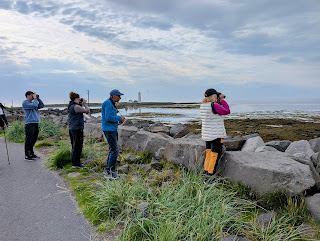

One of the birdwatchers confirmed this was an arctic tern.

Unfortunately, the Friðland Nature Reserve was closed for bird protection from May 1 to July 15, the night we visited! Therefore, we were unable to proceed to Grotta Island, located at the tip of the peninsula.


Next post: Heading northeast from the capital to Bogarnes & the Reykholt Valley.
Posted on July 29th, 2025, from Qaqortok, in South Greenland, a land we knew little about until recently, and which had also received few headlines until a certain politician decided he wanted it! Tomorrow, Steven and I will be on a ferry that will take us up Greenland's west coast for four days, but we will then visit other small settlements on our own until August 13th. Please take care of yourself and your loved ones.


