Showing posts with label North Carolina. Show all posts

Sunday, July 18, 2021

9/26/20: Cherokee, NC: Museum of the Cherokee Indian

Last September, Steven and I stayed for just one night in the town of Cherokee, North Carolina, located at the southern end of the Blue Ridge Parkway. We didn't realize until we arrived that the town was part of, and owned by, the local Indigenous reservation. The main street seemed like one big souvenir store selling native items of every description. Though we did stay clear of the shops, the cutely painted bears caught our interest, even though we'd seen very similar bears a few days ago. Guess they must be a North Carolina 'thing'


The town of Cherokee's Museum of the Cherokee Indian opened in 1948 and was then moved to its current location in 1975. The museum had helped to revitalize the stamped pottery tradition by creating and working with the Cherokee Potters' Guild and bring back traditional dances and traditional 18th-century dress and feather capes. The North Carolina Arts Council presented the museum with the Community Traditions Award as a result of their work.


The statue honored Sequoyah, the Cherokee genius who invented the tribe's alphabet. The statue was carved from one piece of California Sequoia redwood log which was donated and shipped by the Georgia Pacific train company. The sculptor, Peter Wolf Toth, had also created 62 other sculptures in Canada and the US commemorating the Indigenous people in both countries.


The first people in North America were Paleo-Indians and they moved in groups seasonally to hunt animals and gather wild plant foods. There is little of their material culture that has survived over the millennia except for stone tools.


One of the exhibits mentioned Archaic Indians but without any reference to time or era. Because this group grew more knowledgeable about plants, they were able to create a surplus of food without the cultivation of crops. With a more leisurely lifestyle, more time was devoted to tool-making which became more sophisticated.


Archaic Indians used many methods to catch fish - one involved using a net of long grape leaves with small river stones attached at intervals, acting as weights to push the nets toward traps.


Woodland Indians showed a high level of adaptation to the environment, finding new ways to hunt and grow food. Using bows and arrows meant they could hunt a wider range of animals from greater distances. Cultivation of crops, including corn, a mainstay of their diet, and pottery manufacturing became more widespread.


As pottery was bulky, breakable, and tough to transport, it is thought that pottery making was popular for those living in more permanent villages. Pottery has been found with markings on it in what is now Eastern Tennessee that dated to 900 BC.


While Southeastern Indians celebrated festivals throughout the year, none was as important as the Green Corn Festivals when the corn first became ripe or later when it was perfect and mature.


Stickball, a form of Canadian lacrosse, was very popular by all tribes in the Southeast and apparently plaid with great ferocity!


After archaeologists discovered examples of twilled-split cane baskets as well as slippers made of twilled vegetable fiber at a Woodland site in Kentucky, they knew basket-making was common since early times for the Indigenous people of the Southeast. I could hardly fathom that many of the same weaving techniques currently being used by the Cherokee were in evidence as early as 7500 BC!


This 200-year-old, authentic, Cherokee dugout canoe was found in north Georgia in 1974 and donated to the museum.


With the arrival of European settlers, the Cherokee acquired horses which increased their hunting capabilities and transport goods. Trading with the British meant they had axes and hoes to use their land more efficiently and grow crops.


King George III's Proclamation of 1763 promised there would be no more White settlements in the Appalachian Mountains and all points west. We all know that, sadly, it could not be enforced.


The painting depicted the Cherokee Delegation who traveled to London in 1762 to meet the king.
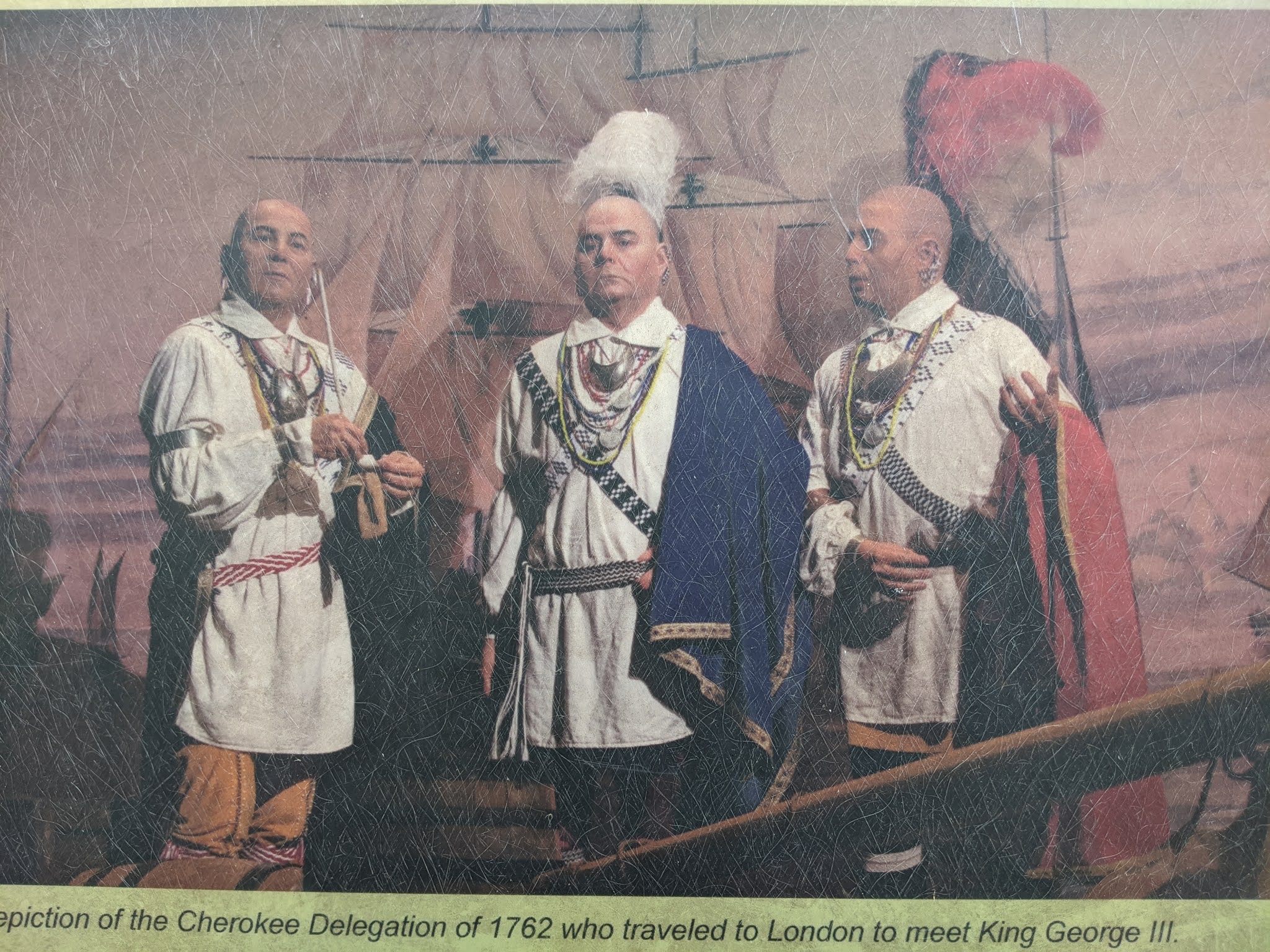

The Cherokee thought they were 'safe' after the king had signed his proclamation but then came the American Revolution.


A Civilization Policy was adopted at the end of the 1780s under President George Washington's rule to transfer the nomadic Indians into farmers. The tribes were expected to adopt the American way of life through individual ownership, worship one true god, speak English, and govern themselves with written laws. All that entailed giving up their culture, tribal organization, and religion.


The policy meant different things to different people: some Whites saw it as 'civilizing' native people; others saw it as a way to gain native land for White settlers as farming would require less land for the Indigenous people. Even the Cherokee weren't united about the meaning of the policy as some wanted to adopt aspects of the White culture and therefore gain respect.


An example of The New Testament translated into Cherokee after their written language was devised by Sequoya. It was thanks to his genius that the Cherokee were able for the first time to keep records in their own language.


The 1830 Indian Removal Act was one of the most horrific acts perpetrated by the US government. More than 16,000 Cherokee were deported from their homelands in four Southern states and relocated to Indian Territory or what is now Oklahoma. That forced relocation was called the Trail of Tears as it resulted in thousands perishing.


Because the Cherokee community of Qualla Town had separated from the Cherokee Nation in 1820, they were not legally required to emigrate on the Trail of Tears to Oklahoma in 1838. Their white patron had received state and federal guarantees for the Qualla Town Cherokees' right to remain in their ancient homeland. 

I wasn't surprised to learn that the US Army still threatened the people of Qualla Town in 1838 when they searched for fugitives from the Cherokee Nation and forced the leader to help the Army find their own kinspeople who were hiding in the mountains. The troops were led on wild goose chases through the Smoky Mountains, far from the hiding places.

After the Army withdrew from eastern North Carolina in November of 1838, hundreds of Cherokee came from their mountain hideouts to join their relatives and friends at Qualla Town. They formed the nucleus of the Eastern Band of Cherokee Indians.


This Cherokee printing press was used during the 1870s and 1880s  and was similar to the one used when the nation's first bilingual newspaper, The Cherokee Phoenix, made its debut.


The Chamber of Dissenting Voices statue represented three faces of the Cherokee and the different paths they took because of the forced removal policies. One represented the Oconalfutee Citizen Indians who had taken advantage of a treaty clause to separate from the Cherokee Nation and live on private reservations on ceded land. 


Though the majority of the Cherokee wanted to remain in their homeland and fought with every legal means at their disposal, their efforts failed and they were forcibly removed to what is now Oklahoma. Their westward journey came to be known as the Trail of Tears and was depicted by the image of John Ross, a Cherokee chief.


Another facet represented the Treaty Party led by Major Ridge, his son, and nephew who signed the Treaty of Echota which ceded their eastern homeland for five million dollars and western land. Because the majority of the Cherokee Nation thought they were traitors to giving up their birthright, they were executed. I thought the three-sided sculpture was a brilliant way to graphically display the horrors of the removal from different perspectives.


I'll say that it's because I was raised in the Canadian school system that I was totally ignorant of the Five Civilized Tribes, the major tribes of the Southeast that were removed from their homelands and transplanted in the West. The tribes were the Choctaws, the Chickasaws, the Creeks, the Seminoles, and the Cherokees. Even though they were considered to be mostly receptive to the Civilization Policy, had adopted agriculture as opposed to hunting, spoke English, sent their children to White schools, had written laws and their own government, they were still forcibly removed. 


The paintings were of leaders of the Five Tribes.


It was horrific to learn of the huge population losses suffered by the tribes during the removal: the Choctaws lost 15 percent of their people; the Creeks and Seminoles lost half of their total population; the generally accepted number of deaths for the Cherokee people ranged from 4-8 thousand people.


In1987 the US Congress established the Trail of Tears Historic Trail to commemorate the tragic removal of thousands of Cherokees to Oklahoma. The trail consists of both a land and water route which are administered by the National Park Service. Perhaps someday Steven and I can explore part of the land trail as it's not something we know anything about. 


The museum had a huge and quite riveting mask collection. One person remarked that people wearing the mask could almost feel the transformation; it was as if they were 'one with the mask.
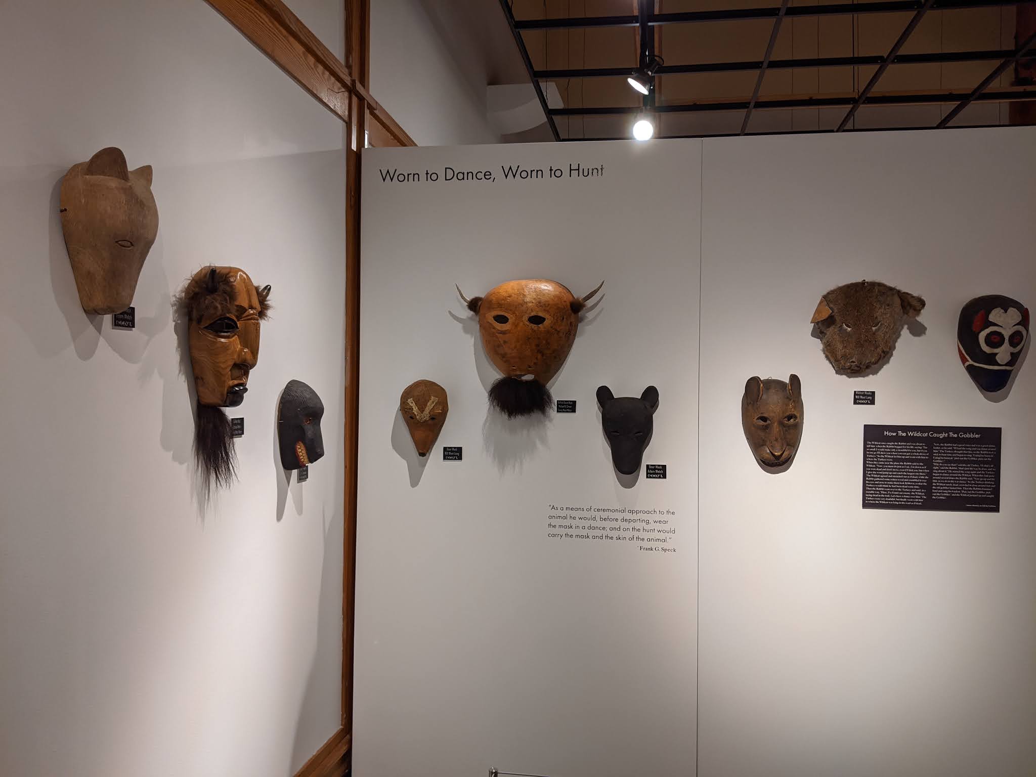


These clan masks were a 20-century phenomenon that had been commissioned by an Indigenous Council to hang in the council house and made for tourists.


The museum took great pride understandably in displaying these sacred masks that had been repatriated from the Seneca Nation in New York state to the Eastern Band of the Cherokee. What was missing for me was the critical explanation as to how the Seneca Indigenous people had come to have the masks in the first place. 


A Cherokee wrote about how essential it was that young people of his nation learn how to make masks so that the culture will survive. Neither of us had been in a museum that so perfectly displayed the Indigenous perspective of one group's culture and history. I wish a visit to the museum were required for all those living in this country to gain a better understanding and appreciation of the Cherokee. 


Next post: Some civil rights sights in Montgomery, Alabama.

Posted on July 18th, 2021, from Atlanta, Georgia, just two days away from our long-awaited beach time in Gulf Shores, Alabama. It will have taken us over five weeks and close to seven thousand miles of driving as we took the most circuitous route possible! I hope you and your loved ones are healthy even as the Delta variant is gaining ground on the pandemic.

Tuesday, July 13, 2021

9/25/20: Great Smoky Mountains National Park

Considering Steven and I had just spent the last two days driving the phenomenal Blue Ridge Parkway from the midpoint to the southern terminus, it was amusing seeing the parkway entrance sign for visitors going northbound outside the town of Cherokee, North Carolina! We looked without success for the last marker on the Parkway just as we did the night before - drat.


We hadn't been lucky enough to see any elk on the Parkway so were thrilled to spot this one grazing nearby by the entrance to Great Smoky Mountains National Park. The 520,000-acre park, divided between North Carolina and Tennessee, received its name from the Cherokee people who described these mountains as shaconage which meant the "blue, like smoke" haze that hangs over the mountains.


In the background were some very atmospheric shots of the haze playing hide and seek with the mountains!


After visiting the park's visitor center, we walked around the Mingus Mill, an elaborate and still-working 1886 turbine mill.


The National Park Service bought the mill from the Mingus family in the 1930s. A small steel turbine provided power to operate the mill's stones and machinery in place of a wooden water wheel. The mill still operates as an historical exhibit during the summer. When I commented to the guide inside the mill how dark it was, he replied that he'd been looking for lights there since 1866!


For nearly half a century, nearby farmers brought their corn and wheat to the mill which charged them a toll normally one-eighth of the amount of grain brought for milling. The gristmill's stone was turned by a water-powered, cast-iron turbine


The water adjacent to the Mingus Creek Trail was running very fast that September day.


A flume channel carried water directly to the mill.


Steven and I were relieved the center part of the trail had been raised up to allow for the water to collect on either side only.


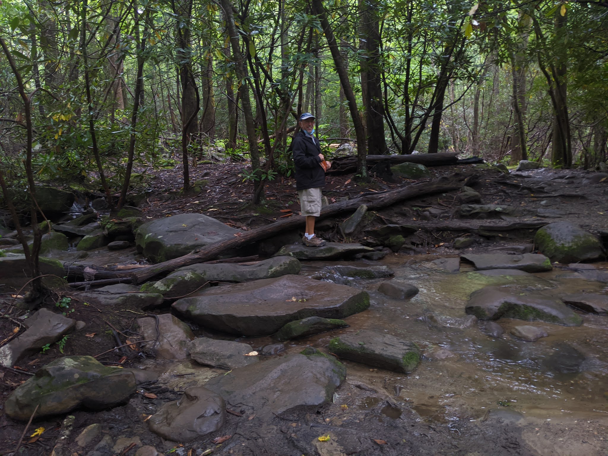
Since the park receives so much rain, there were many vibrant shades of green everywhere we looked.


Although we knew it was raining, there was so much tree canopy it was like we were under a giant umbrella the whole hike!


It was marvelous making a return visit to the national park as few places in the country have such a variety of vegetation. The mountains catch the region's copious rainfall, resulting in a variety of plant and animal species, including more tree species than northern Europe, 1,500 flowering plants, dozens of native fish, and over 260 birds and mammals. This remarkable biological diversity and the cultures humans have used from its abundance has led to the park being designated an International Biosphere Reserve and a World Heritage Site!


At the park's Cut and Run Lookout, there wasn't much to actually look at because we were up among the clouds! If we'd been here over a century ago, there would have been a far different view as huge chestnut, hemlock, and oak trees once stood tall on the mountainsides. The lookout's name came from loggers' cut-and-run attitude in the early 1900s of quickly cutting trees before moving on to the next stand as there seemed to be inexhaustible timber resources.  


Lumber companies owned 85 percent of the land that became the national park and actually logged 65 percent of it. So alarmed was Congress at the commercial threats to the forests, it authorized the park in 1926 which was among the first to be assembled from private lands. 


Loggers, some with families, often lived in portable housing known as "set-off houses."


Though the Great Smoky Mountains were ancient, much of the forest was young or never cut. As much as 80 percent of the forests had been cleared by loggers and farmers by the time the park was established. Farmers had cut many old-growth forests, clearing fields for pastures and cropland. The Great Smokies' old-growth forests were home to several record specimens as the size of some tree species wasn't exceeded elsewhere. But while some trees were huge, old-growth didn't necessarily result in big trees as harsh conditions on ridge tops meant 500-year-old trees might just be six inches in diameter.


Rugel's Ragwort was one plant found nowhere else on earth. After being cut off from its northern relatives during the continent's glacial advances 15,000-10,000 years ago, it now lives exclusively in spruce-fir forests.


I read that plants and animals on the Spruce Fir Trail needed to survive in harsh, high-country conditions. At this elevation, rain and snow are heavy, winds can be biting, and temperatures are often frigid. How sad to learn that a non-native insect is decimating the Fraser fir, a primary component of this forest. That will result in impacts felt by the entire forest community.


Walking the trail was great practice to improve our tightrope walking skills!


Steven and I joked that couldn't the National Park Service have sprung for two more boards along the trail to make it a tad wider!


Lettuce anyone?!


We'd initially planned to continue driving another five miles along the park's scenic highway to Clingman's Dome but the weather was just too miserable so we turned back toward Newfound Gap. We figured there wouldn't have been a thing to view from atop the dome with the reported zero visibility. 


Great Smoky Mountains National Park was a grand experiment as never before had a national park been created by purchasing private lands. In the 1920s and 1930s, however, the states of North Carolina and Tennessee plus the support of thousands of people across the country purchased 6,000 tracts of land and then transferred them to the federal government. 


On September 2, 1940, in the Newfound Gap section of the park, President Franklin Roosevelt dedicated the park from this platform. "We meet today to dedicate the mountains, streams, and forests to the service of the American people" 


A plaque installed in 1984 stated, "In commemoration of 50 years of excellence in conservation, restoration, and enjoyment."


At Newfound Gap, we hiked an almost laughably short distance of the Appalachian Trail or AT, one of the longest continuous footpaths in the world. The AT winds its way more than 2,150 miles in 14 states from Maine to Georgia. Hikers report that few stretches are more remote or difficult than the section through the Great Smokies because the trail follows some of the highest ridges in the mountains.


As we walked along the AT for a bit, we happened to chat with two fellows who were just returning from hiking 30 miles of the trail and it had taken them four days. 


We looked pretty happy last September considering how miserable the weather was!


We passed some lovely falls and streams as we then headed north through the park toward Gatlinburg, Tennessee.


As there was essentially no view to speak of at the Carlos Campbell Overlook, we trudged on and found some quite marvelous views of huge ferns a short distance ahead.


Even though it was still only late September, the city of Gatlinburg was definitely all ready for Halloween! I know we'd driven a long way cross country from Colorado to Illinois, then south to Florida, and up through North Carolina during the height of the pandemic last year but I was still amazed at the gobs of people in downtown Gatlinburg. With the absence of masks and many people not practicing social distancing, it was quite uncomfortable being anywhere close to such crowds. 


Being able to escape far from the madding crowd seemed essential. We hightailed it to the Noah 'Bud' Ogle Place, also in the park, so we could go on another self-guided nature trail. The first settlers changed the mountains with axes, plows, and guns, cutting into forests that were centuries old. They called this area Junglebrook for the dense growths of rhododendron and magnolia trees that bordered the streams. This was Ogle's farm from 1883 until 1925 but it looked as if the first might be reclaiming it now!


In 1879, the Ogles were among the first to settle in the backwoods community of White Oak Flats, now Gatlinburg. They started out with 400 acres even though a land assessor declared it wasn't fit for farming.


As their family expanded, the house was added on with a chimney set in the middle so both halves would be kept warm!


Chestnut blight in the 1930s killed these trees.


Reading the signs: The Ogles would have known the temperature by looking at the rhododendrons - as it drops to freezing, the leaves begin to darken in color and droop. Around 20 degrees Fahrenheit, they start to curl, and at 0 degrees, they start to roll up tight and turn inwards toward the stem. This may all seem like some useless bit of trivia until one realizes that it was only by listening to Mother Nature's cues the Ogles and others had health and food. Disregard for the elements would mean hunger and misery. 


Getting by with less: Nothing went to waste for people of an earlier age. When a piece of land was too rocky to be cultivated but not rough enough to remain a forest, it might be used as a pasture. The family derived dairy products from very marginal land as survival depended on each kind of ground for its maximum potential. Even the rocks didn't go to waste. They would have been used as stone walls to keep cows in place. The key was turning nuisance materials like the rocks into something useful.


Leaving the nest: As children married, they moved out of the home. This pile of rocks further along the trail was what remained of the 'honeymoon' or 'weaner' cabin where newlyweds were permitted to live for one year until they established their own abode. It sure was hardly The Ritz, was it!


Unusual for this era and place, the Ogle family had running water but it wasn't through metal pipes. Wood, the handy and accessible product, was made into a wooden trough that carried water from the spring all the way to the house. There it got dumped into a double wooden sink that had been hewn from a large log.


Living with all of our 'mod cons' made me realize how extraordinarily lucky we are. Life couldn't have been easy for the Ogles a hundred years ago as they eked out an existence.


We retraced our steps through Gatlinburg hoping to go to the Arrowmount School of Craft and Design, a gallery that used to showcase some top-notch items from all over the Appalachian region. I was pretty disappointed it was closed until Steven said he thought he could find a shop we had lucked out first discovering about 25 years ago called Whaley's Handcrafts. It and many other small shops were located outside of town in a thriving arts community. We had been back to Whaley's twice since our initial discovery and had also ordered a custom table runner and I was thrilled to return one more time. 


Over time we'd purchased well more than a dozen mini wooden vases with intricately carved wooden flowers, wooden bowls, and some beautiful, hand-woven textiles all made by Randy Whaley, his 85-year-old father, his son, Scott, and also his cousin. The last thing I needed was any more placemats and another table runner but I happily bought them anyway for old times' sake. The shop had no curb appeal but its exterior belied the superb quality of each of their handiwork.


It was a long and pretty harrowing drive in the mist back through the park to Cherokee in North Carolina where we'd set out from early that morning.


Steven, God love him, found the last milepost on the Blue Ridge Parkway that we'd tried to locate twice the preceding day to no avail! He is incredibly persistent and vowed not to give up without finding Milepost 469 - I was so happy to capture the photo. In just a week or so, Steven and I will be starting to drive the Blue Ridge Parkway again but this time from the northern starting point. I am so curious to see how it will compare with all that we experienced on the southern stretch last September.


Next post: Museum of the Cherokee and Montgomery, Alabama Civil War Sights.

Posted on July 13th, 2021, from Annapolis, Maryland, on the east coast as we ever so slowly wend our way from Denver toward the Gulf states of Alabama and Florida for some beach time.