

On our way to the Waimea Canyon on Kauai's South Shore, Steven and I stopped at the Hanapepe Valley Lookout where we had a marvelous view of the red cliffs that are referred to in the town's Hawaiian name.

A little further west on the South Shore was Russian Fort Elizabeth State Historic Park although the word "Russian" was blackened out on the sign. I wondered whether that was done recently as part of a pro-Ukraine rally? According to one story, the name of the park comes from the stone fort, built in 1816 by Anton Schaffer, an agent of the imperial Russian government, when he tried to conquer Kauai for his homeland. Others believe Scheffer's loyalty lay with Hawaiian King Kaumualii who was attempting to wrest leadership of his island from Kamehameha the Great.

As Scheffer was part of the Russian-American Company (RAC), the fort was named after Russian Czarina Elizaveta. It was never built or occupied by Russian soldiers, however. Once the RAC was expelled from the island in 1817, the name Fort Elizabeth fell out of use and the Hawaiian name for the fort, Pa'ula'ula, was used. That name wasn't reflected on the sign, though.
The first recorded landing of Westerners in the state of Hawaii was the arrival of Captain Cook's two ships into Waimea Bay in January of 1778. After being met by several hundred Hawaiians in canoes, Cook stayed in Waimea for six days and traded nails and glass beads for water, hogs, sweet potatoes, and bananas.

The fort, located at the mouth of the Waimea River, was an important cultural and historical site because high-ranking Kauai chiefs lived there. The high chief repeatedly met with European explorers and traders beginning in the 1780s. After the chief made an alliance with the RAC, the Hawaiians built Russian Fort Elizabeth with Hawaiian materials and building techniques but with a European design.

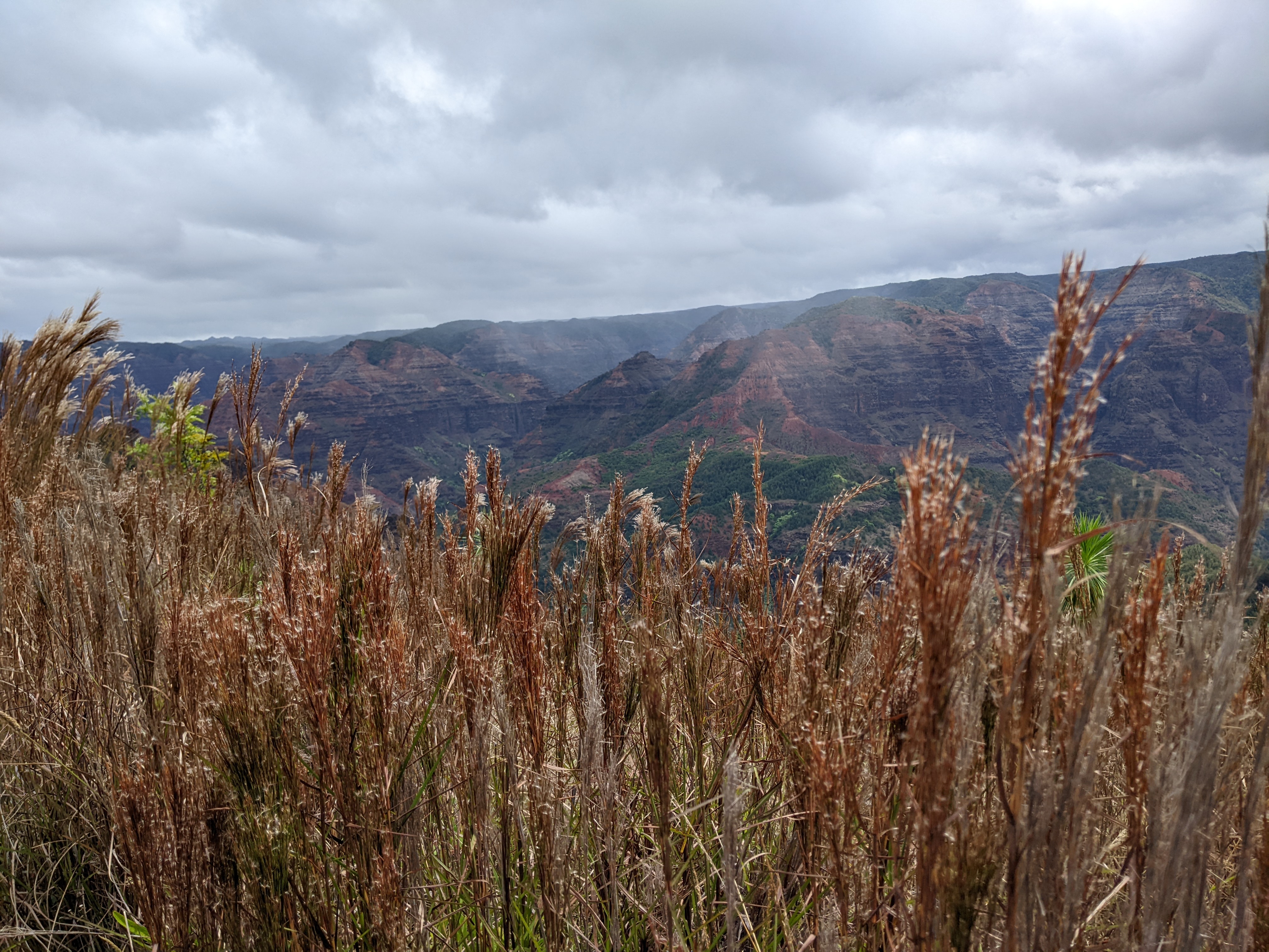
There was essentially nothing left of the fort now to see - just a row of rocks and some short walls in the distance behind the grasses.

The statue was of Kaumualii, King of Kauai and the neighboring island of Niihau, from about 1778 to 1824. The statue faced the direction of the setting sun on the day of the Spring Equinox, the approximate direction over the horizon of the western border of the Kauai Kingdom. From this vantage point, the king was able to enjoy both the sunset of the Winter Solstice on his left and the Summer Solstice to his right.

We walked across an empty field where we guessed the fort had been and saw some steps in the distance.


We realized later that the rock steps provided access to where cannons had once been at the top of the wall. For us, they meant a pleasing view of Waimea Bay.

A mile or so down the road was the serene town of Waimea that the captain had pointed out on our boat tour of Napali Coast the previous day. The town was far livelier than Hanapepe, the so-called "historic town" and Biggest Little Town on Kauai, we'd also stopped in the prior day. That may have been because of the historic role it played with Cook's arrival and also as the place where King Kaumaualii acquiesced to King Kamehameha's unification drive in 1819 which averted a civil war. As the town also hosted the first Christian missionaries, its residents have taken great pride in their history and heritage.
The neoclassical First Hawaiian Bank of 1929 anchored the commercial district and its steps have been a stage for community gatherings.

The statue in the town square honored Captain Cook who put Waimea and the state of Hawaii on the world map. If we ever make it to Cook's hometown of Whitby in northeast England, we will see the original of this statue!

Within five years of Cook's arrival in Waimea, the world knew of Hawaii's existence and the town as a suitable port of call because the explorer's journals became best-sellers in Europe. After trying to find the Northwest Passage, Cook returned to Hawaii in 1779 where he was killed on the island of Hawaii during a conflict with the islanders.


The Waimea Church of Christ, also called the Great Stone Church, was an imposing building that sat on a knoll a little north of town. It was built in the mid-1850s and had a distinctive covering of coral. Its rather lurid history included a minister being expelled by the Hawaiian Supreme Court after his "suspect theological positions and reports he had illicit relations with a Hawaiian woman."

From Waimea, we made our way to Menehune Ditch which caught our attention because it was rumored to have been built by Hawaii's 'little people,' the Menehune, who arrived around 300 AD from the Marquesas Islands! Some legends say the seven-mile aqueduct that channeled water from the Waimea River to ancient agricultural sites was constructed in one night! Some believe the stones used to complete the ditch were brought from nearly six miles away. The Hawaiian culture that is present today was built seven hundred years later by the Tahitians.

Walking very gingerly across the hanging bridge by the ditch made me realize I now had had enough of hanging bridges after two days in a row, even as peaceful as beautiful as the views from it were!

The ditch was first described by Captain George Vancouver in 1793 as standing 23-feet-tall with its top serving as a pathway into Waimea Canyon.


Kekaha Lookout, the first lookout on the famous Waimea Canyon Drive, was extremely unusual as there were pretty amazing lookouts on both sides of the road.


Looking along Kauai's South Shore in both directions from the lookout:


The next lookout, Niihau, was just two miles further along the Waimea Canyon Drive where again we were treated to superb views on both sides of the road. Niihau was the neighboring island across the bay.


A view of Waimea River winding its way through the canyon:

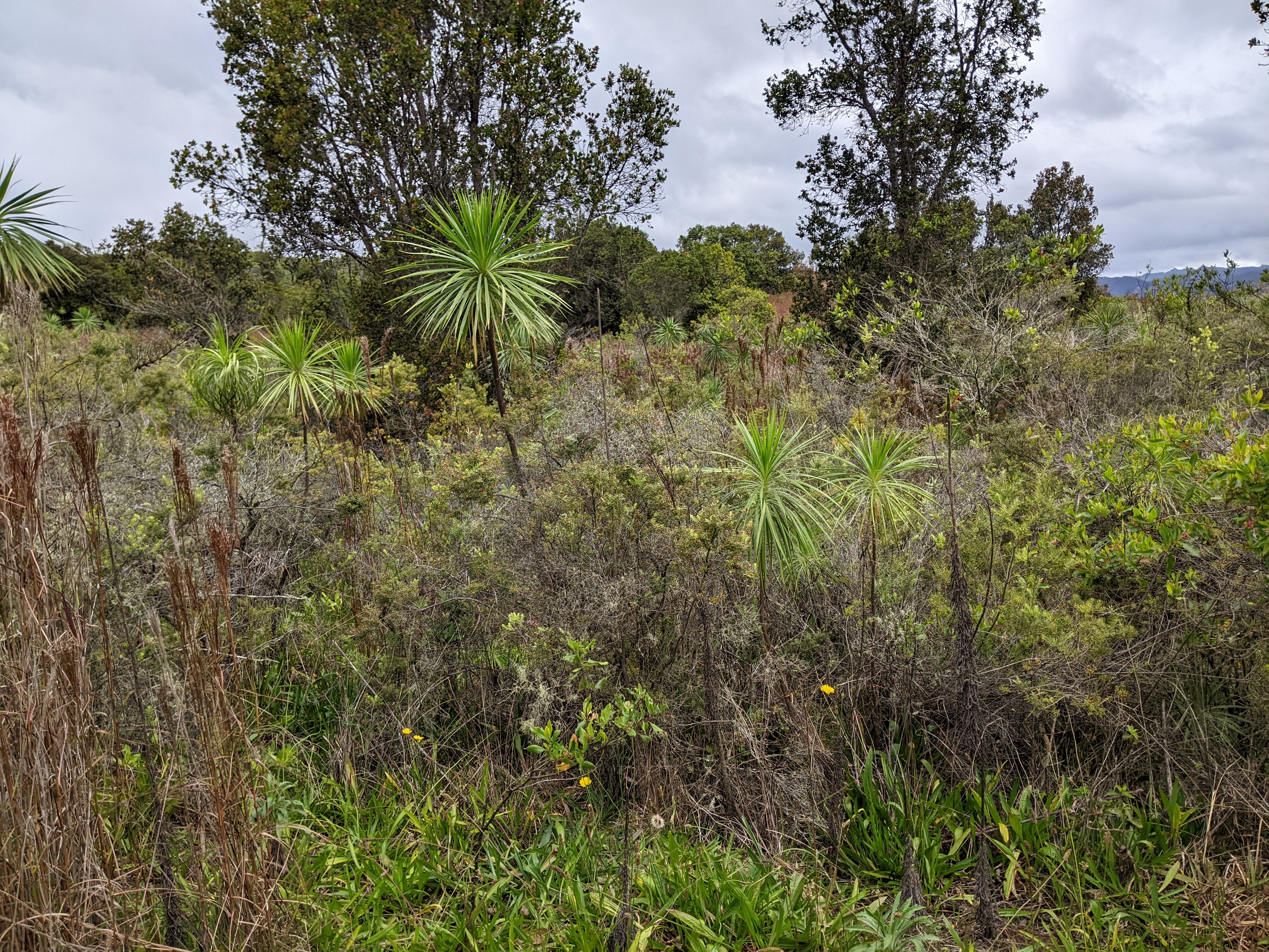
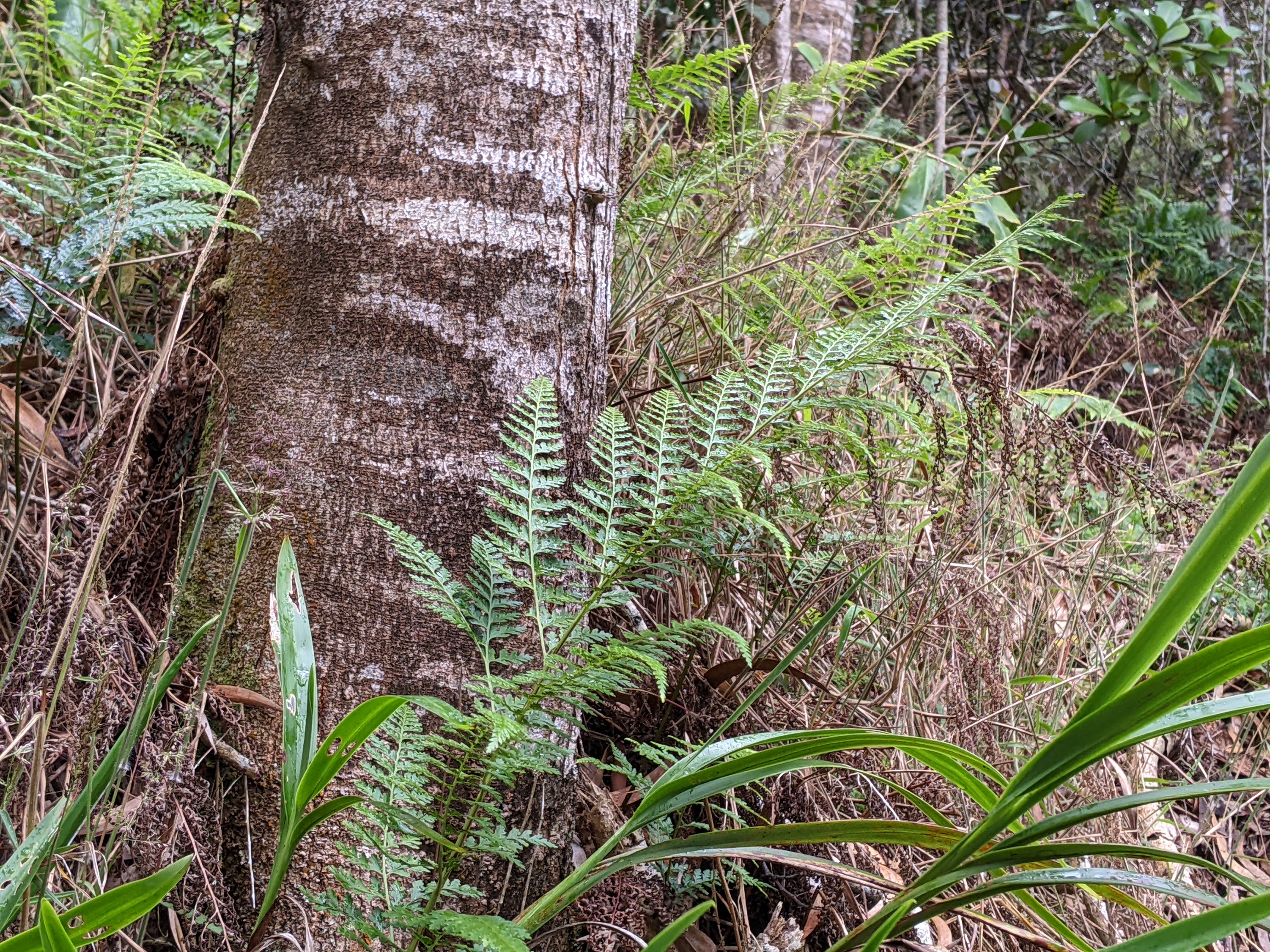
A sign at the Iliau Nature Loop indicated the Hawaiian Archipelago is the most remote island chain in the world and it gave birth to some of the most unique and biologically diverse plant species on the planet. The loop was a rare opportunity to observe and learn about some of Hawaii's native plants which could be indigenous and/or endemic. The plants have continued to play an important cultural connection between the land and the people of Hawaii.
The trail was named after the Iliau botanical species that was only found on Kauai. An ancient member of the sunflower family, the iliau lives for about 20 years before it flowers and blooms into an immense flowering stalk with daisy-like flowers from May to July just once before dying.

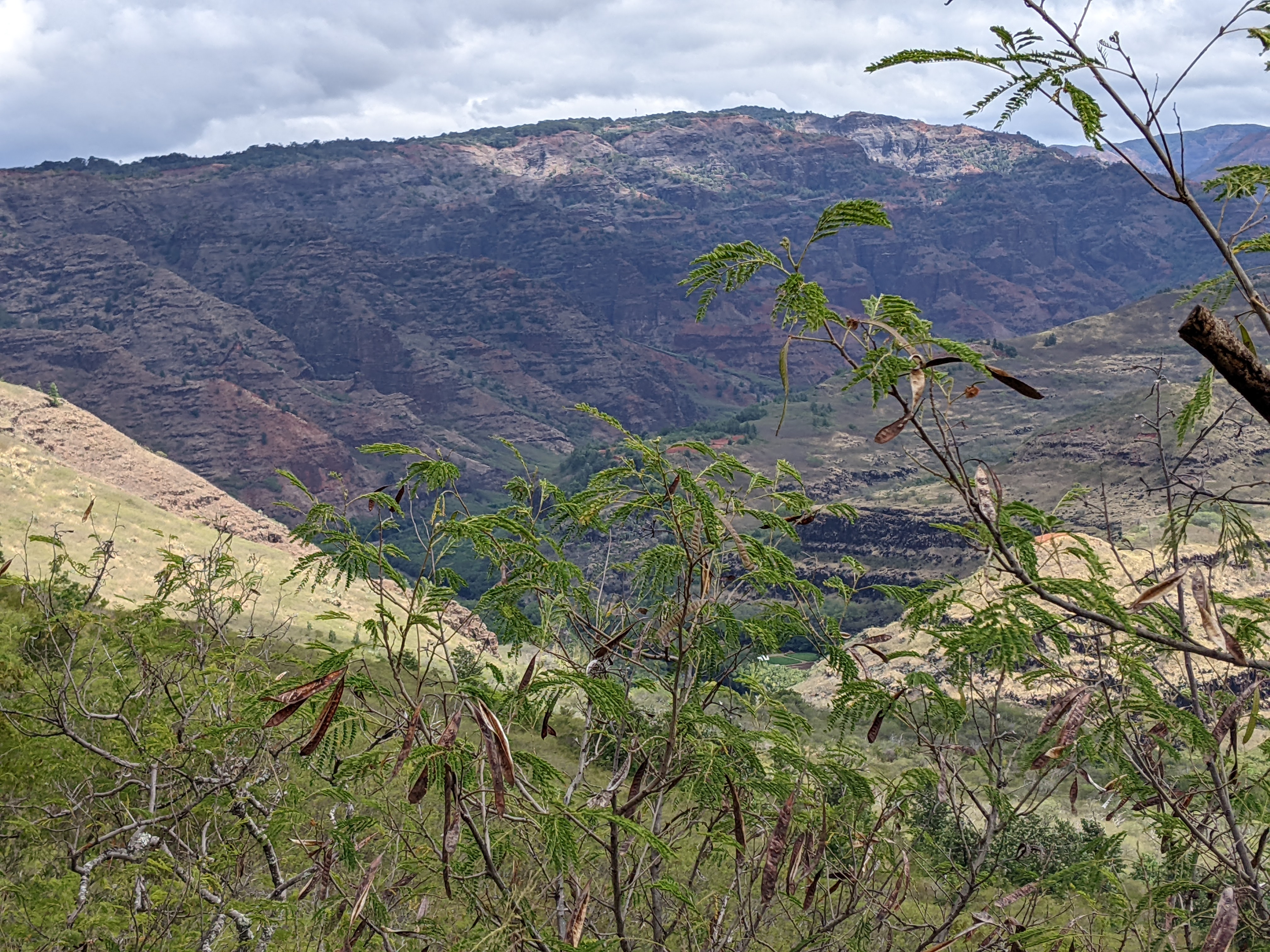
We could see here how Waimea received its Hawaiian name as it meant "reddish water," a reference to the erosion of the canyon's red soil
One of the main species of Hawaiian native forests was the Koa tree which meant "strong and brave." The trees with their sickle-shaped leaves can grow up to 115-feet tall and 6-feet in diameter. The red hardwood was valued by ancient Hawaiians for its trunk which was used to build their dugout canoes. The wood is now used for furniture, bowls, and ukuleles.


The Kaweku native perennial grass is found on all the Hawaiian islands from the sand dunes in coastal areas to cliff sides in the uplands. The waving of kawelu grass in the breeze is said to be the inspiration for the hula step. The grass is also mentioned in many Hawaiian chants and poems.

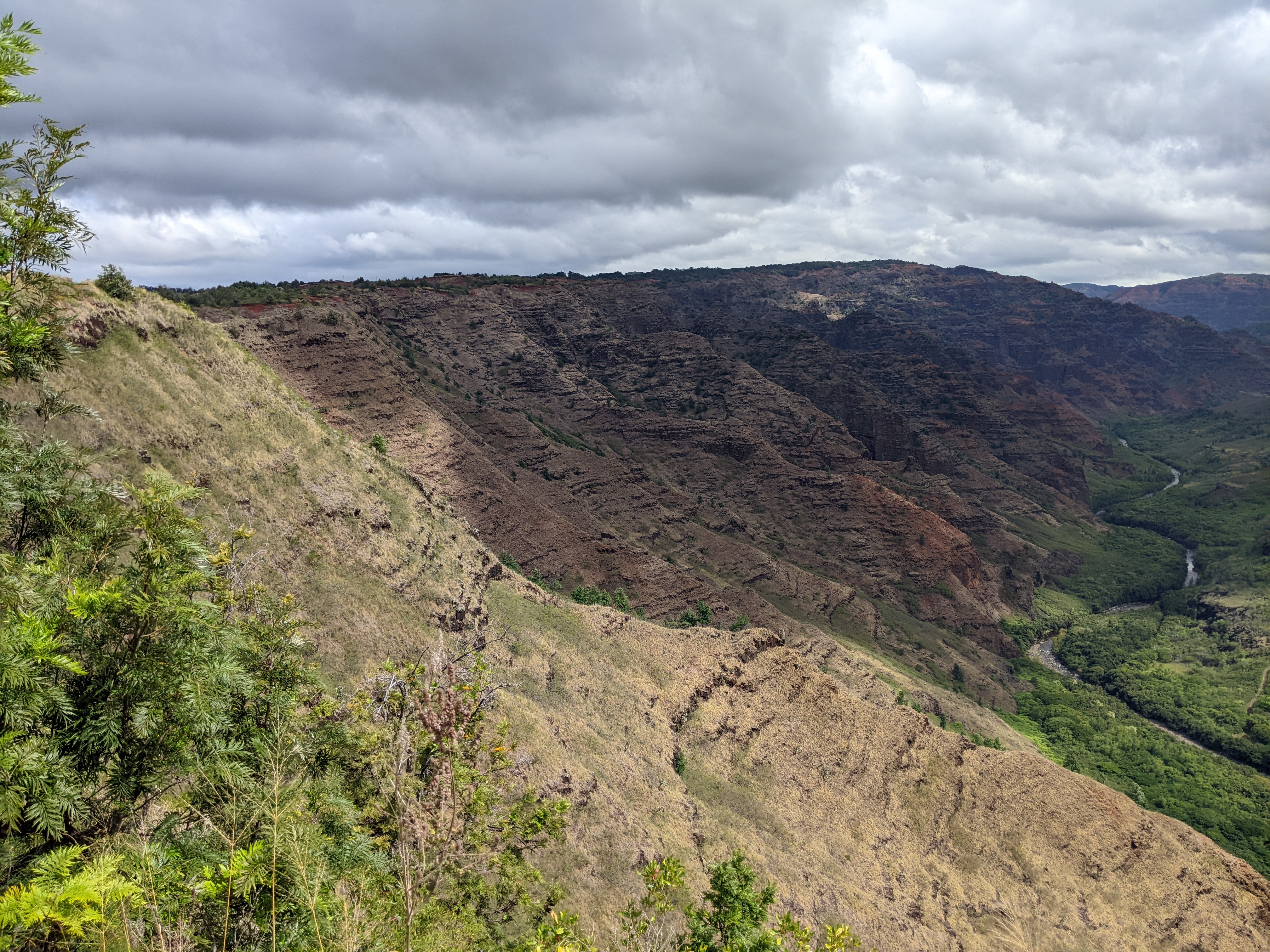
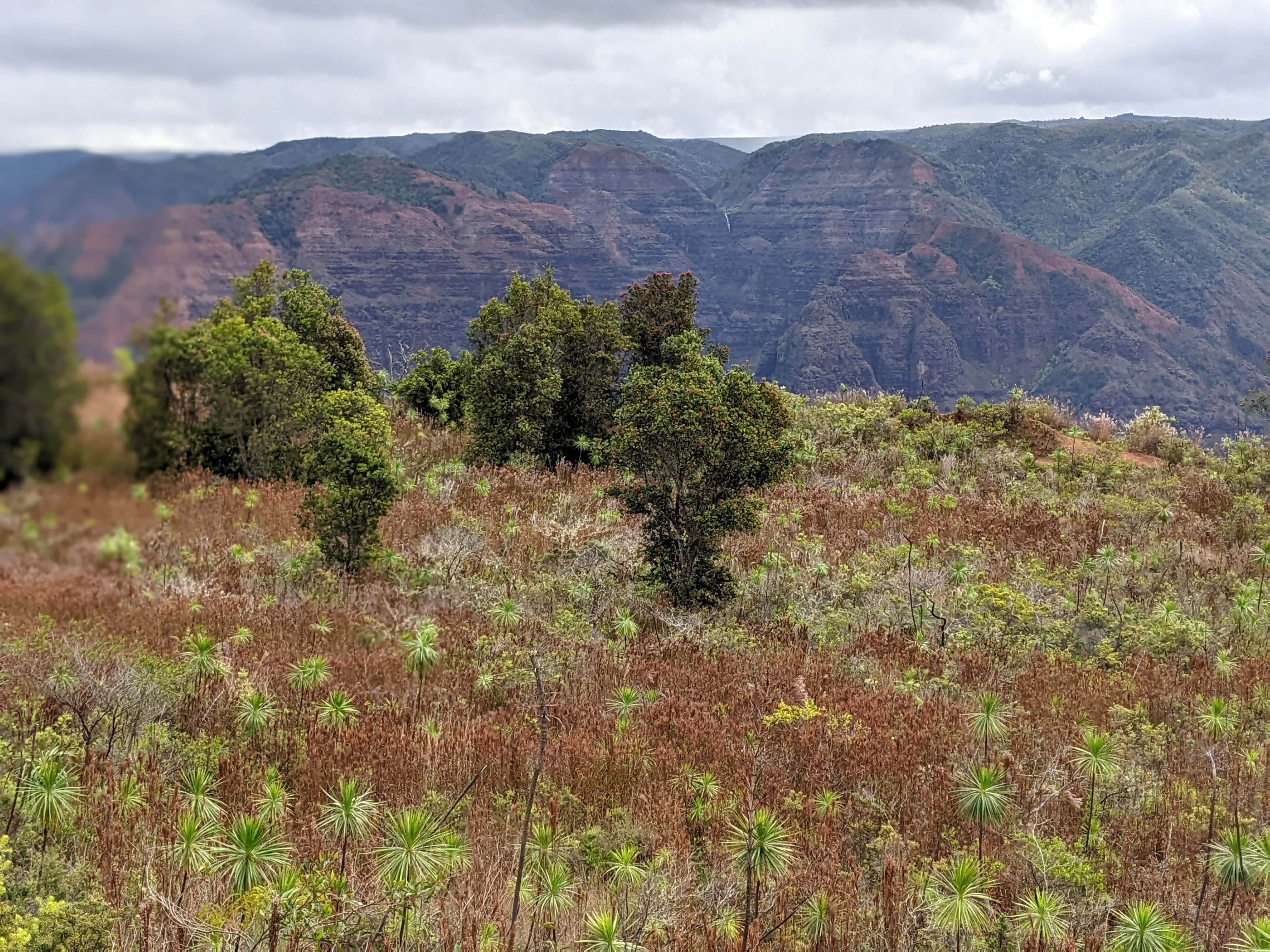
The moniker, the “Grand Canyon of the Pacific” for Waimea Canyon was falsely attributed to Mark Twain. It became popular after American explorer John Wesley Powell came to the island of Kauai in 1869. Carved over countless centuries by the forces of wind, rain, and the Waimea River, the canyon is a dramatic gorge 3,600-feet deep, 2 miles wide, and 10 miles long. The canyon's red colors indicate where water has seeped through the rocks, pulling mineral dust from the iron ore inside.


Uki, a large sedge with brown feathery seed heads endemic throughout the state except for Molokai, is used in wreaths and floral arrangements. The leaves were used as an inner lining for the walls of ancient Hawaiian houses called hale.

The Pukiawe shrub, indigenous to the main Hawaii islands, has tiny, stiff leaves that were used medicinally for colds and headaches. The plant's inedible berries and flowers are used in making leis. When the ali'i or high priest liked to mingle among his people, he'd walk through burning pukiawe smoke to free himself of kapu or forbidden things.

Though the nature loop was short, the views of the canyon had been exceptional and the plant signage informative.


We turned in next at the Waimea Canyon Lookout where we had yet more panoramic views of crested buttes, rugged crags, and deep valley gorges. The grand inland vistas went on for miles.


The 10-mile-long Waimea River enters the ocean at the town of Waimea which translates to "red water" and likely refers to the reddish-brown, acid-rich water that originates in one of the bogs.


The horizontal layers and colors we saw on the canyon walls were from a series of lava flows that have occurred over the past four to five million years. Trees have been able to grow along the lower slopes where both soil and water are present. By contrast, the rocky slopes and ridge tops tend to be dry and barren.


The island's highest peaks, Wai'ale'ale and Kawaikini, are at over 5,000 feet. The former is one of the earth's wettest spots with an average of 420 inches of annual rainfall.


From the lookout, we had our first glimpse of Waio'o Falls, an 800-foot-high cascade that continues to erode the steep canyon. To get any closer, we would have to have taken a helicopter ride as even from the end of the Canyon Trail, you can only see the pools above the falls.

People have been traveling to the Kauai's uplands to enjoy Waimea Canyon for more than 100 years. It was an all-day adventure to reach this spot by horseback before 1920. The journey was made much easier when cars and roads arrived on the scene after 1920.

The road to the canyon was paved in the 1940s followed by the construction of the lookouts. Visitation then increased dramatically in the 1960s.


Further up the road at Pu'u Ka Pele Lookout, we got another view of the falls on the Waimea Canyon Drive. Though we were still a remarkable distance away from the falls, it was still a beautiful photo opportunity.

We wondered how much more 'gorgeous' the gorge could be?!


Once we reached the Canyon Viewpoint at the Pu'u Hinahina Lookout, it was evident the higher elevation meant more clouds were rolling in and our visibility was noticeably less.


I didn't mind the mist and fog as both lent an air of mystery to the canyon.

Near the end of the drive was the Kokee Natural History Museum where we followed its Nature Trail. The loop was described as an example of what the forests in this part of the park looked like prior to the introduction of grazing animals and plant pests. We were first asked to request permission from Laka, the goddess of the forest and the reproductive energy that allowed plants to grow and thrive. Asking permission to enter either silently or out loud was a form of respect as is done before picking or harvesting plants. When making leis, Hawaiians often honor the area around the harvested plants as a gift from Laka.


Loulu was the only endemic palm in the Hawaiian islands. It is in decline due to feral pigs and rats who eat their seeds and shoots. Hawaiians used the leaves as thatching material.

The Ohe'ohe (Don't you love Hawaiian names?!) plant is rare on all the islands except Kauai. A member of the Panax family which includes English ivy, ginseng, and umbrella trees, it can range from 24 to 75 feet with large leaves at the top of naked stems. Its name literally means "uplands."

The 'Ama'u tree fern has edible curled shoots and a nearly non-existent root system which allows them to be easily uprooted by feral pigs. The 'ama'u was one of the ferns that Kamapu'a, the pig god, could take at will!


At Kalalau Lookout, we learned that Kalalau was the largest valley along the Napali Coast. Hawaiians lived and farmed in Kalalau for centuries, cultivating over 200 acres on the valley floor. Their thatched hale or houses lined the shoreline and lower slopes of the valley. It was common for many families to move to the beach during the summer. Farming continued into the 1800s with a population of around 200. In 1864, horses brought into the valley transported the harvested taro to the beach where it was loaded on ships heading to Hanalei and Waimea.

Because of a fog bank that had rolled in, we saw nothing, nada, zilch of Napalai's characteristic fluted cliffs, of Kalalau Beach, of the 11-mile trail that ended in the valley, or of Kalalau Stream and the valley floor. All of that was left up to our and, therefore, your imagination!


Looking on the bright side, we were so, so lucky that there was no rain or mist blocking our sight of the incredible canyon views until the last two lookouts.

I couldn't believe how quickly we zipped down the extraordinary Waimea Canyon Drive as it had taken us a few hours to explore the lookouts and do some hiking on the way up. In almost no time we again had familiar views of the ocean.


Next post: Another national tropical botanical garden & Menehune Fishpond!
Posted on April 16th, 2022, from San Francisco Airport just before we board our flight home to Denver after being in Hawaii for the last month or so. It will be fun to sleep in our own bed, reconnect with friends, attend daily water aerobics classes, etc before the lure of the open road takes us away in a few weeks.
Very stunning topography esp. the Waimea Canyon. It rivals or surpasses the Grand Canyon. So much beauty on the island .
ReplyDeleteIndeed, so much beauty on the island, John! Glad you can see why we were so stunned by the gorgeous views of the canyon.
ReplyDeleteIn another lifetime we lived just outside of Honolulu for a little over a year. It gave us a chance to explore a few of the other islands. Your photos capture Waimea Canyon very nicely. Hope you had an uneventful flight/trip home.
ReplyDeleteWelcome to the post/blog, Patti. Glad you liked how I captured the stupendous beauty of Waimea Canyon.
ReplyDeleteAnnie
I love Kauai and the Waimea Canyon!! Your photos are inspiring me to go visit there again. Janina
ReplyDeleteMusic to my ears, Janina!
ReplyDelete