Sadly, the heaps of trash continued to be a familiar sight as Steven and I drove from Sciacca west along the coast toward Selinunte, a town known for its numerous ruined Greek temples. The town is named after a local variety of wild celery that grows in profusion each spring.
Selinunte, one of ancient Greece's most important colonies, was recently discovered to have been home to the largest industrial area in any European city. Established in the 7th century BC, the city became prosperous through trade and the manufacture of ceramics. In 400 BC, a Carthaginian army razed Selinunte, which had been sent by its rival, Segusta, to be destroyed. The temples were demolished, and 16,000 of its inhabitants were massacred.
The rest of the complex was 2.5 km away.
A picture to add to my collection of unusual bathroom photos from around the world!
The modern discovery of the remains of Temple E-Heraion is traced to 1823 when two young British archaeologists found the temple's famous sculpted metopes, the rectangular architectural elements that adorned the outside of Doric temples. The only part of the sanctuary still standing was a portion of one wall. It remained that way until the 1950s when the temple was almost entirely rebuilt.
The diagram imagined what the temple would have looked like in its heyday.
Unlike at the temples at nearby Agrigento, visitors were surprisingly welcome to stroll among the temple ruins.
Seeing the assortment of capitals and blocks around the temple made me wonder if this was a puzzle-maker's dream or nightmare! Recent discoveries by archaeologists have included pots with the remains of food inside, proof that some people were in the middle of eating when the attacking Carthaginians arrived.
Burn marks still scarred Greek columns, and much of the site remained in rubble in the same collapsed position.
A pillar from Temple F, dating from the late Archaic age, may have been dedicated to Athena, Hercules, or Dionysius. Temple E is in the background.
Olive groves surrounded the temples and ruins.
The pile of rocks, formerly known as Temple G-Olympieion, was one of the largest in the Greek world. It was built to compete with the large Ionic temples in Asia Minor. Archaeologists have determined, from an inscription dating to the mid-5th century, that it was dedicated to the Olympian deities and other major deities of the city: Zeus, Apollo, etc. I remain stupefied that archaeologists could determine that one of the ancient world's major temples existed from what we saw in front of us.
It's too bad there weren't any young children around, as they would have loved clambering among the piles of rocks!
In the middle of the ruins and temples was a small museum.
Inside was a portion of the recreated 6th-century BC Temple Y with the menotes, the sculptures at the top. Archaeologists determined that many of the temple's elements were readapted for reuse. Although the building's original location remains a mystery, enough of it was preserved to permit its general reconstruction.
The floral decorations dated from the Corinthian period, 590-570 BC.
The terracotta Statue of a standing female figure was from the second quarter of the 5th century BC.
Remarkably, the roof fragment from Temple E, which dates to the middle of the 6th century, still had faint coloring. I wondered how archaeologists knew the fragment was attributed specifically to Temple E and not any other temple.
The image shows what a more complete version would have looked like.
Fragment of an Attic red-figure krater, circa 500 BC:
The elegant, Enthroned temple goddess dated to 500-480 BC.
No less than Jean-Paul Sartre opined that the temples of Selninute had more weight than many words.
The map shows the proximity of southern Sicily to Carthage in present-day Tunisia, which we'd be exploring after Malta.
Steven and I chose to forego touring the other two sections of the archaeological park as we were "templed out" at that point in the trip and we knew we had more to view later on!
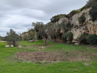
We drove next to Casa di Cusa, a limestone quarry 11 km northwest of Selinunte. Ancient Greek builders prized the limestone because it was a stronger and more resistant construction material than the fossilized shells abundant in local stone. The quarry's current name refers to Baron Cusa, the area's former owner. However, in the 18th century, it was known by its Arab name, Ramuxara. The quarry, used since the first half of the 6th century BC, was abandoned when mining began and also with the advancement of Hannibal's army in 409 BC.
Historical engravings at the end of the 18th century hypothesized the entire stone removal and transportation process. First, the rocks' surfaces were cleaned and sanded. Then, a circular channel was dug around the rock to make the stonemason's work easier. The rocks were then detached using metal wedges. They were transported to the building site on sleighs with wooden wheels pulled by draft animals. Finally, the rocks were carried along a nine-to-ten-meter-wide rocky road that is no longer visible due to land transformation.
As we wandered through the gorge, we came across broken discs and rocks that had been cut and then abandoned.
Viewing and being able to touch the marks made by tools that were centuries old with no one else around was an extraordinary experience.
Next post: Marzala del Vallo's Dancing Satyr Museum & Kasbah later in the day.
Posted on January 26th, 2025, from the Chicago suburb of La Grange, where we came for the weekend to help celebrate our youngest granddaughter's second birthday. If you're in chilly parts of the world, stay warm, and please take care of yourself and your loved ones.


No comments:
Post a Comment