
Driving westward from Los Alamos to tour some of the pueblos, Steven and I soon came to the massive and magnificent Valle Grande, which was formed about a million years ago after tremendous volcanic eruptions ejected superheated ash and lava more than 500 times greater than the May 1980 eruptions of Mt. St. Helens. That followed more than 13 million years of volcanic activity in the Jemez Mountains. Minor volumes of magma leaked to the surface "just" 50,000 years ago, forming these dome-like hills between us and the opposite wall of the enormous Valle Caldera.
Others at the lookout spotted elk in the distance, but we weren't so lucky.

A view of the impressive Jemez (pronounced Hemess) Mountains near the Jemez Pueblo:


The highway ran right through the 89,000 acres belonging to the Jemez Pueblo community of 1,800 tribal members who settled here in the late 13th century. Before the Spanish arrived, the Hemish, literally "the people," which the Spanish spelled Jemez, had established more than ten large villages in the area. Because Jemez absorbed members of Pecos Pueblo in 1838, it celebrates two feast days in addition to Pueblo Independence Day, commemorating the Pueblo Revolt of 1680. It's also the only remaining pueblo where residents speak the Towa language, the rarest of the related New Mexican languages.

Beyond the church were the ruins where the Franciscan friar and likely a few converted Jemez assistants conducted church business, cooked and ate meals, and slept. Classes were also held to teach trades, religion, and the Spanish language. Imagine how lonely it must have been for the Spanish priests stationed so far from home, with few people speaking their language.


Our view of the ruins from a hill overlooking the site was a good time to ponder that historical sources about Gisewa and the mission are often contradictory and confusing. As the brochure we purchased stated, "Perhaps, as archaeological and historical methods improve, future research will reveal Gisewa's true past."


Outdoor enthusiasts must love the area south of the historic site, as there was one campground, picnic site, and fishing hole right after another along the road rimmed by vivid red sandstone cliffs.


A sign requested that people not take photos to the west, i.e., to the left of this photo, because it was sacred land where tribal members were buried. The only local man we saw in the pueblo saw us wandering around and mentioned that wood had to be hauled from the mountains to build the church before the priest agreed to come. I wish I had asked him why the Laguna people chose to have a priest come instead of having Catholicism foisted on them by the Spaniards.

The almost deserted road, definitely not a highway, toward the Acoma Pueblo could only be described as otherworldly, with spectacular, mammoth rock outcroppings in every direction!


The view of Acoma Pueblo from the overlook as we headed west took our breath away.

Almost immediately, the terrain changed drastically, with volcanic stone on the lava-strewn landscape. El Malpais, literally meaning the "badlands," was the product of three volcanic events, the last of which occurred millennia ago, so wildflowers stood out against the jagged black rock.


Steven was a little too close to the edge for my comfort!


The monument's land provides geological wonders galore as a protected volcanic region. However, there were still likely remnants of WW II military training activities hidden within. Kirtland Army Air Field bombardiers used it as a bombing range, dropping live and practice bombs on it. That was only stopped in 1944 when the terrain was considered too rugged to construct and maintain targets.


At 125 feet high and 165 feet across at the base, the arch was the second largest in the state. La Ventana or "the window," was comprised of Jurassic Zuni Sandstone, formed 160 million years ago from sand dunes that covered the area. Wind, rain, and ice have eroded the sandstone over time to create the arch!

Steven and I have been so lucky to view other magnificent arches all over the world, some of which have collapsed due to the forces of nature. Will visitors to this area of west central New Mexico still be able to see this marvelous natural arch in another hundred years, in another five hundred years?

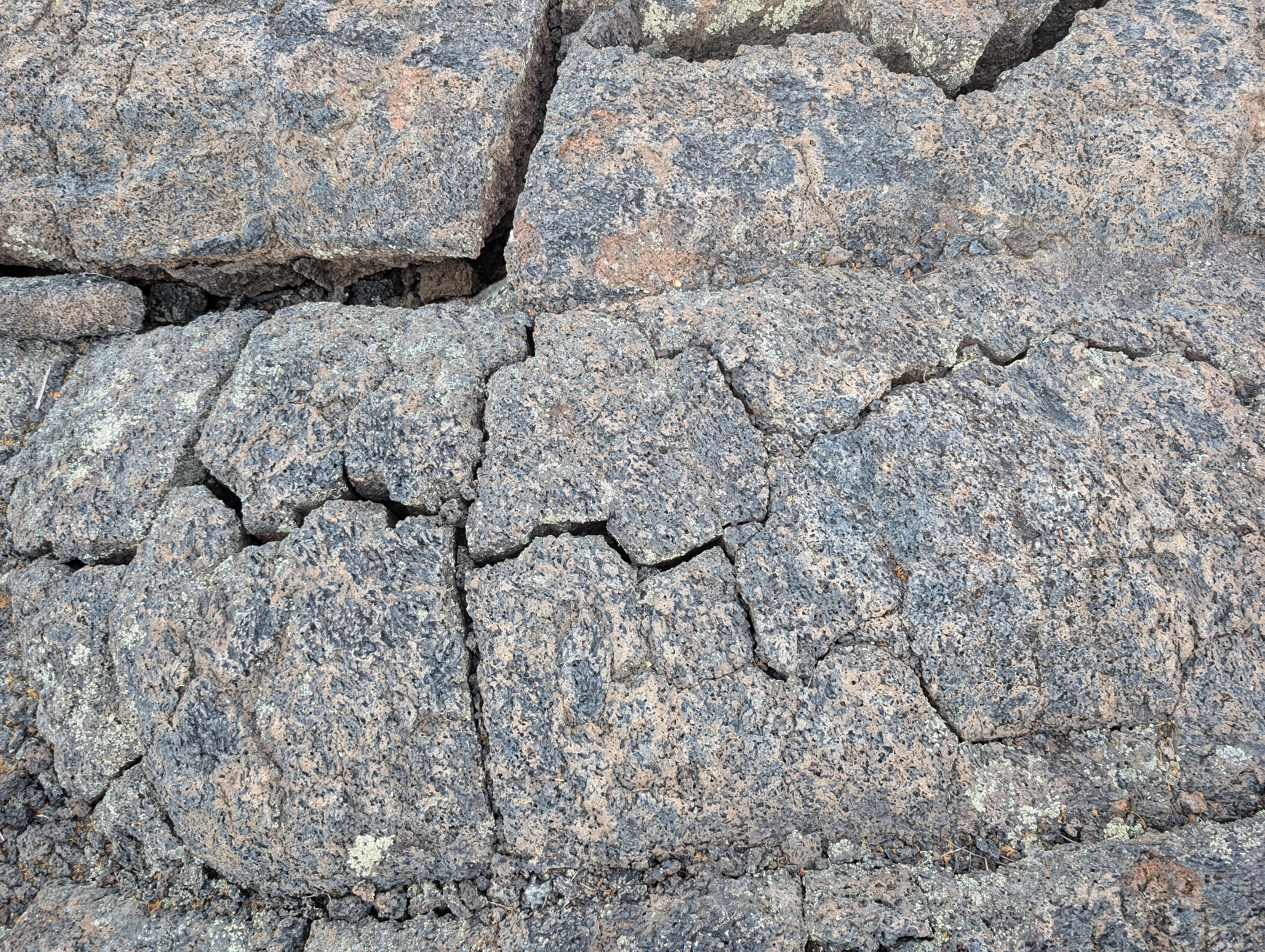
Even though the park's Visitor Center had long closed for the day, we drove further south to the Lava Falls Area. It was the youngest lava flow in the monument, as about 3,900 years ago, multiple vents and a shield volcano ejected molten lava. It looked like the swirls of lava had just cooled the day before! Steven was more eager than I to hike the trail - the uneven lava surfaces were not my friends! Plus, the suggestion in our guidebook that we carry a compass in case we lost sight of the rock cairn trail markers didn't make me feel warm and fuzzy right then.


It was hard to grasp that the Sandstone Bluffs, the La Ventana Natural Arch, and the Lava Falls Area were all part of the one national monument, as they were strikingly disparate geological areas!


Next post: Pioneers leaving their mark at El Morro National Monument and much more!

A view of the impressive Jemez (pronounced Hemess) Mountains near the Jemez Pueblo:

A couple of curves later on the winding road, we reached the rocks of Soda Dam. The pale, bulbous mineral blobs made me think of the top of a root beer float with a waterfall crashing through the middle! The groundwater comprised minerals including calcium, carbonate, and travertine.

The highway ran right through the 89,000 acres belonging to the Jemez Pueblo community of 1,800 tribal members who settled here in the late 13th century. Before the Spanish arrived, the Hemish, literally "the people," which the Spanish spelled Jemez, had established more than ten large villages in the area. Because Jemez absorbed members of Pecos Pueblo in 1838, it celebrates two feast days in addition to Pueblo Independence Day, commemorating the Pueblo Revolt of 1680. It's also the only remaining pueblo where residents speak the Towa language, the rarest of the related New Mexican languages.
The wooden map on the engraved wood floor of the Jemez Historic Site encouraged tourists "to stand, walk, and embody the site, including the ancient village of Giusewa and the San Jose Mission."


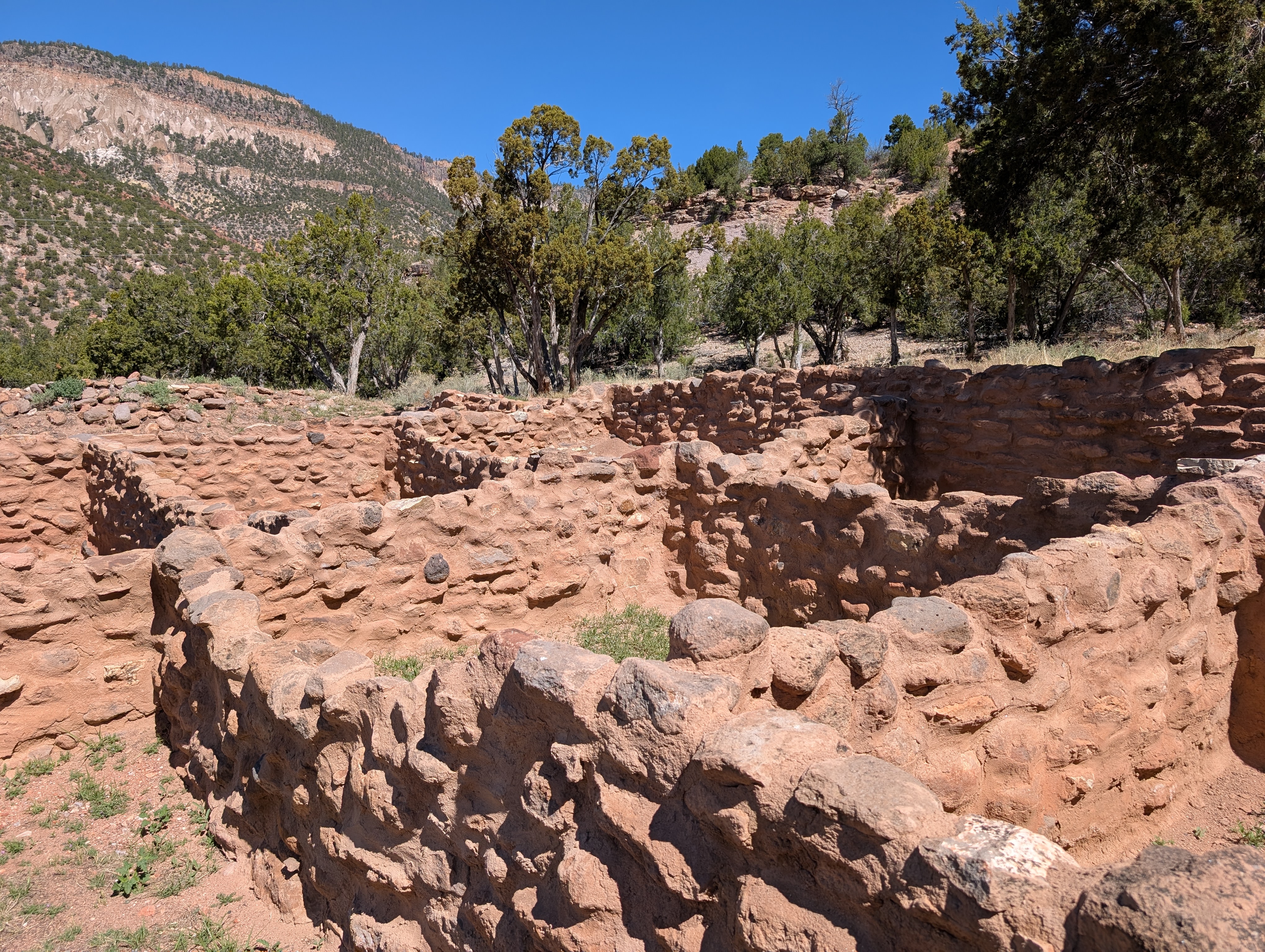
Though Fray Alonzo de Lugo was the first missionary assigned to the Jemez area in 1598, it isn't known whether he or his immediate successor began the actual missionary work at Gisewa. Two attempts at Christianizing the Jemez (in 1601 and 1621-23) failed. The San José de los Jémez Mission church was founded in 1621-22 and was constructed of sandstone except for a few sections of adobe brick. The ruins of the once-imposing complex are proof of the religious zeal of the 17th-century Franciscans, who were responsible for building most of the mission churches in the American Southwest.


While professional architects and engineers brought building knowledge during the first decades of Spanish colonization in Mexico and South America, that wasn't the case in 17th-century New Mexico. As there were no secular building experts among the colonists, the friars were forced to rely on their memories of the fine churches in Europe and Mexico and translate those memories to the land in New Mexico.

The church interior measured 33 feet by 110 feet, and the walls were 6 to 7 feet thick. Fresco paintings, painted pine panels, and carved wooden statues of saints would have adorned the interior. We could still notice how the floor sloped toward the altar. After a fire in 1623 destroyed much of the interior, a new two-story facade was built. To say I was impressed by the scope and detail of the church, considering it was based only on the friars' recollections of what churches back home looked like, is an understatement!

Beginning a self-guided trail of the site, we learned that it protected the ancient village of Gisewa and the San José de los Jémez Mission. Gisewa was a thriving 14th-century village for at least 200 years before the arrival of the Spanish. The village was the present-day Jemez Pueblo, a sovereign nation of 3,400 members, about sixty percent of whom live on tribal land. It was one of the largest and most impressive pueblos in the Jemez area. All that remains of the pueblo are mounds of dirt and rock that mark the ancient homes' locations.

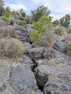
The kiva was a special and sacred place used for ceremonies and social gatherings by Pueblo people. The structures were usually round and underground to represent the underworld. A hatchway through the roof above the fireplace was a ladder entrance and an opening for smoke to escape.
In the winter of 1540-41, Francisco Vasquez de Coronado and his entourage of 400 Spaniards, at least 1,500 Native American allies, four Franciscan friars, and dozens of African slaves overtook a village 40 miles southeast of Gisewa. An exploration party reported visiting the pueblo, and in 1598, Spanish settlers were led by friars to colonize and Christianize New Mexico. Sadly, we read that the friars often destroyed kivas in their search for souls.

These partial walls were all that remained of a three-story apartment-like block of pueblo rooms that attached to a kiva on one corner,

Though Fray Alonzo de Lugo was the first missionary assigned to the Jemez area in 1598, it isn't known whether he or his immediate successor began the actual missionary work at Gisewa. Two attempts at Christianizing the Jemez (in 1601 and 1621-23) failed. The San José de los Jémez Mission church was founded in 1621-22 and was constructed of sandstone except for a few sections of adobe brick. The ruins of the once-imposing complex are proof of the religious zeal of the 17th-century Franciscans, who were responsible for building most of the mission churches in the American Southwest.
The Campo Santo, or cemetery, was usually located in front of the mission church. It was customary for Christian converts at Franciscan missions in Spanish colonial New Mexico to be buried in a cemetery surrounded by a low wall.

While professional architects and engineers brought building knowledge during the first decades of Spanish colonization in Mexico and South America, that wasn't the case in 17th-century New Mexico. As there were no secular building experts among the colonists, the friars were forced to rely on their memories of the fine churches in Europe and Mexico and translate those memories to the land in New Mexico.

The church interior measured 33 feet by 110 feet, and the walls were 6 to 7 feet thick. Fresco paintings, painted pine panels, and carved wooden statues of saints would have adorned the interior. We could still notice how the floor sloped toward the altar. After a fire in 1623 destroyed much of the interior, a new two-story facade was built. To say I was impressed by the scope and detail of the church, considering it was based only on the friars' recollections of what churches back home looked like, is an understatement!

Beyond the church were the ruins where the Franciscan friar and likely a few converted Jemez assistants conducted church business, cooked and ate meals, and slept. Classes were also held to teach trades, religion, and the Spanish language. Imagine how lonely it must have been for the Spanish priests stationed so far from home, with few people speaking their language.

The Sacristy in the foreground held the priest's vestments, linens, and other items used for worship. In the rear was the octagonal Bell Tower.

Other views made us appreciate how the architecture helped create maximum awe among the local Jemez. However, it's critical to understand that the massive complex is one of many symbols of the brutality of Spanish colonialism, as it was built only with forced labor.

Though there are limited written records of the church, the Gisewa people likely attended Mass three times a day, a practice common at other missions. Though the Spanish invested substantial effort in the mission at Gisewa, it was abandoned in 1640 after just twenty years.

Our view of the ruins from a hill overlooking the site was a good time to ponder that historical sources about Gisewa and the mission are often contradictory and confusing. As the brochure we purchased stated, "Perhaps, as archaeological and historical methods improve, future research will reveal Gisewa's true past."

The National Oceanic & Atmospheric Administration established this Jemez Springs Weather Station in 1910. The name seemed grandiose for the tiny structure at the trail's end!

Outdoor enthusiasts must love the area south of the historic site, as there was one campground, picnic site, and fishing hole right after another along the road rimmed by vivid red sandstone cliffs.


Before arriving at the Laguna Pueblo two hours later, Steven and I stopped at the acclaimed Laguna Burger at the 66 Pit Stop gas station for one of their "ragged (hamburger) patties made of fresh, never-frozen beef, buns toasted on the griddle, and hand-cut fries, with skins on." No way were we going to pass that place up after such a pitch!


Unlike at the Jemez Historic Site, the Laguna Pueblo did not have signs, information, a walking tour, etc., to direct interested people to its San José Mission Church, which was established in 1699. Unlike any other pueblo, the Laguna people requested a priest but were told they needed to build a church before a priest came. The stark white stucco coating was a relatively recent addition after a 19th-century addition. It was mudded and whitewashed annually until the 1950s, when a local uranium mining boom didn't allow time for that maintenance.


Unfortunately, the church doors were locked, so we could not admire what's been described as a "finely wrought wood ceiling ...with icons inside a crowded field of decorative borders and carved and painted columns, creating a work of explosively colored folk art ..."

Behind the church, Our Lady of Victory Shrine honored "All the Laguna boys who died in World War II."


A sign requested that people not take photos to the west, i.e., to the left of this photo, because it was sacred land where tribal members were buried. The only local man we saw in the pueblo saw us wandering around and mentioned that wood had to be hauled from the mountains to build the church before the priest agreed to come. I wish I had asked him why the Laguna people chose to have a priest come instead of having Catholicism foisted on them by the Spaniards.

The almost deserted road, definitely not a highway, toward the Acoma Pueblo could only be described as otherworldly, with spectacular, mammoth rock outcroppings in every direction!


Anyone wishing to visit the pueblo atop a flat-topped mesa must first stop at the Sky City Cultural Center and Haak'u Museum. What a world of difference between the Laguna Pueblo, a few miles away, which looked like people could barely eke out a living, and the ritzy Acoma visitor center, which has a cafe, artisans selling local crafts, and an upscale museum. I wonder if Acoma's apparent wealth was because anyone wishing to tour the pueblo had to take a fairly pricey guided bus tour to the mountain-top village. The road to the top was a concession to modernity - before, all goods had to be hauled up near vertical cliff faces.


As it was already 3ish, we didn't have "time" to wait another hour for the last 90-minute tour to begin, as we still wanted to tour El Malpais National Monument before reaching the town of Grants that night. I could imagine what a moving experience it would be, arriving at the mesa top, feeling the winds gusting through our hair, learning how the village had been built, walking among the adobe homes, seeing the Church of San Esteban, one of the most iconic Spanish missions in New Mexcio, and viewing the vast distances below.

The view of Acoma Pueblo from the overlook as we headed west took our breath away.

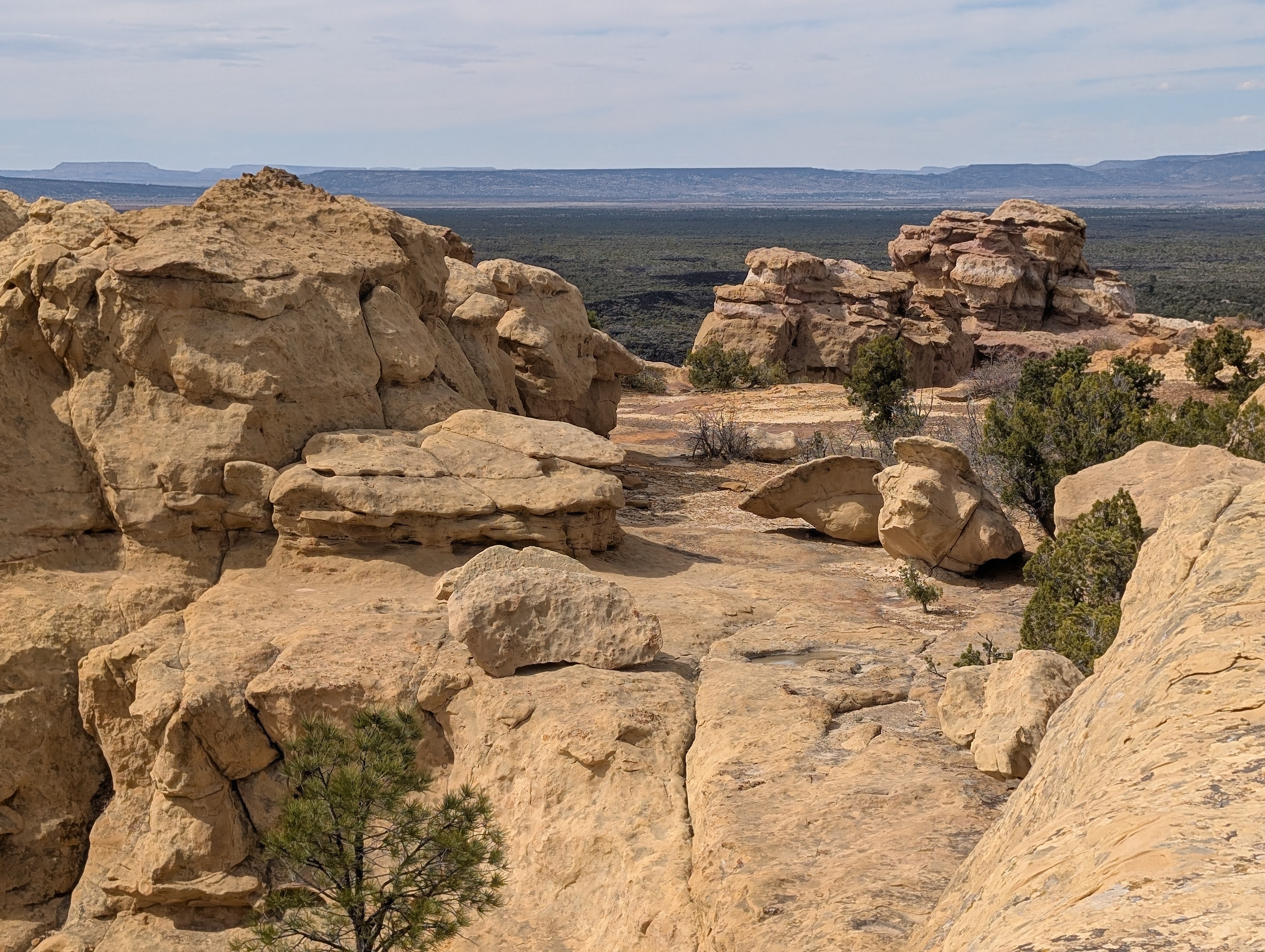
Almost immediately, the terrain changed drastically, with volcanic stone on the lava-strewn landscape. El Malpais, literally meaning the "badlands," was the product of three volcanic events, the last of which occurred millennia ago, so wildflowers stood out against the jagged black rock.


We got our first glimpse of the humongous lava fields at the Sandstone Bluffs Overlook.


Steven was a little too close to the edge for my comfort!


The monument's land provides geological wonders galore as a protected volcanic region. However, there were still likely remnants of WW II military training activities hidden within. Kirtland Army Air Field bombardiers used it as a bombing range, dropping live and practice bombs on it. That was only stopped in 1944 when the terrain was considered too rugged to construct and maintain targets.

En route to the monument's next attraction, La Ventana Natural Arch:


At 125 feet high and 165 feet across at the base, the arch was the second largest in the state. La Ventana or "the window," was comprised of Jurassic Zuni Sandstone, formed 160 million years ago from sand dunes that covered the area. Wind, rain, and ice have eroded the sandstone over time to create the arch!

Steven and I have been so lucky to view other magnificent arches all over the world, some of which have collapsed due to the forces of nature. Will visitors to this area of west central New Mexico still be able to see this marvelous natural arch in another hundred years, in another five hundred years?

Even though the park's Visitor Center had long closed for the day, we drove further south to the Lava Falls Area. It was the youngest lava flow in the monument, as about 3,900 years ago, multiple vents and a shield volcano ejected molten lava. It looked like the swirls of lava had just cooled the day before! Steven was more eager than I to hike the trail - the uneven lava surfaces were not my friends! Plus, the suggestion in our guidebook that we carry a compass in case we lost sight of the rock cairn trail markers didn't make me feel warm and fuzzy right then.

Small ponderosa pine trees dotted the lava landscape. Though they appeared young from their small size, they might have been hundreds of years old, but they were stunted and gnarled from the harsh environment.


On the right was one of the rock cairn trail markers that was so easy to miss.

About halfway along the trail, I finally said I had had enough of the uneven terrain. I didn't feel safe and didn't trust myself not to fall. Steven, strangely enough, had no issues on the trail even though he was still recovering from back surgery and was using walking sticks. Go figure!

Even though New Mexico is relatively close to us in Colorado, El Malpais had never been on our radar before we planned our itinerary of the Land of Enchantment. Thank goodness, we finally rectified that omission.

Next post: Pioneers leaving their mark at El Morro National Monument and much more!
Posted on May 21st, 2025, from Las Cruces in southern New Mexico, another of the state's gems that we're already hoping to return to again next spring! Please remember to take care of yourself and your loved ones.
The massive rock outcroppings dotted along the road to Acoma Pueblo , while unexpected are equally remarkable. Thank you for sharing the fabulous day you had, both on foot and on the road ! xo Lina xo
ReplyDeleteThanks, Lina, for taking the time to comment on yet another of my posts - that means so much! The outcroppings we encountered were stunning, all the more so, I think, since they appeared almost out of nowhere! Love and hugs right back at you, dear friend.
ReplyDelete