Steven and I had spent the second night of our month-long Northwest US road trip in Ely, Nevada, a town near the Utah border that was founded in 1868 as a silver mining camp. The town came into its own at the beginning of the 20th century with the arrival of the Nevada Northern Railway. The town's population exploded when it converted to large-scale copper mining. If we had more time in Ely, it would have been a lark to look for the outdoor murals and sculptures created by artists from all over the world that depicted local history. This one was of the legendary Pony Express.


In July, 1986, Life magazine described Nevada's Highway 50 from Baker in the eastern part of the state to Dayton way out west as the "loneliest road in America." The magazine even suggested that drivers have "survival skills" to travel the route. The highway was also dubbed The Pony Express Trail and the Old Lincoln Highway. Steven and I had stopped in Baker the morning before prior to exploring the nearby Great Basin National Park. As we headed the length of the 'loneliest road' in Nevada we certainly hoped we didn't need any survival skills on the mountainous route!


The first town we came to was Eureka whose heyday in the 1870s led it to be called the "Pittsburgh of the West" based on its lead-based economy and attendant smelters. The town's population, which at one point reached 11,000, supported 100 saloons, several newspapers, hotels, an opera house, five fire companies and a brass band!
The Eureka County Courthouse, built in 1879-80 at a cost of $38,000 of locally-fired brick and of sandstone quarried nearby, was a great example of boom town Victorian opulence. This historic site reflected the glory days of 1864-1890 when Eureka was the first important lead-silver district in the US. Unfortunately the building was closed so we couldn't look at the large courtroom located upstairs that had a bench made of imported Spanish cedar.

Steven and I didn't realize when embarking on this road trip that there was indeed a Highway 50 Survival Guide! The guide was really a passport that could be stamped at historic sites in the major towns along the way. Hokey as it may sound, I was excited at getting the passport stamped in at least five towns and then an official Highway 50 certificate. However, I soon realized that traveling on the loneliest road in America on a Sunday unfortunately meant that most official stamping stations were closed. I was bummed!

Also on Main St. was the renovated Eureka Opera House which dated to 1880 and now also served as a convention, visitor and cultural arts center. In the 1990s, Eureka began to preserve its rich history with the restoration of the Opera House. We were delighted it was open that Sunday morning in June, especially when we were invited to take a private tour with a woman who had emigrated from Colombia just like my dear sister-in-law in Canada.

The plaque outside the Opera House confused us until we learned that AL stood for Anno Lucis or Year of Light and came from the Masonic Calendar which accounted for the 4,000 year difference.

Maria explained that the former stage had burned down but had been lovingly rebuilt. The room's chandelier used to be gas lit.


When she took us behind the stage, Maria pointed out the signatures of people who had performed at the Opera House.


Every inch of the walls in another part of the Opera House was also highly decorated by more current performers. Thanks to Maria, we had a greater understanding of her adopted town's Opera House.

Who knew there were so many other towns also called Eureka in the US?!

The 'E' on the mountainside represented Eureka.

Some other photos from Eureka:


It was heartwarming seeing how the small town of Eureka publicly heralded its hometown graduates who had been accepted into military service.


The mural honored a Basque immigrant and sheep herder who made Eureka home.

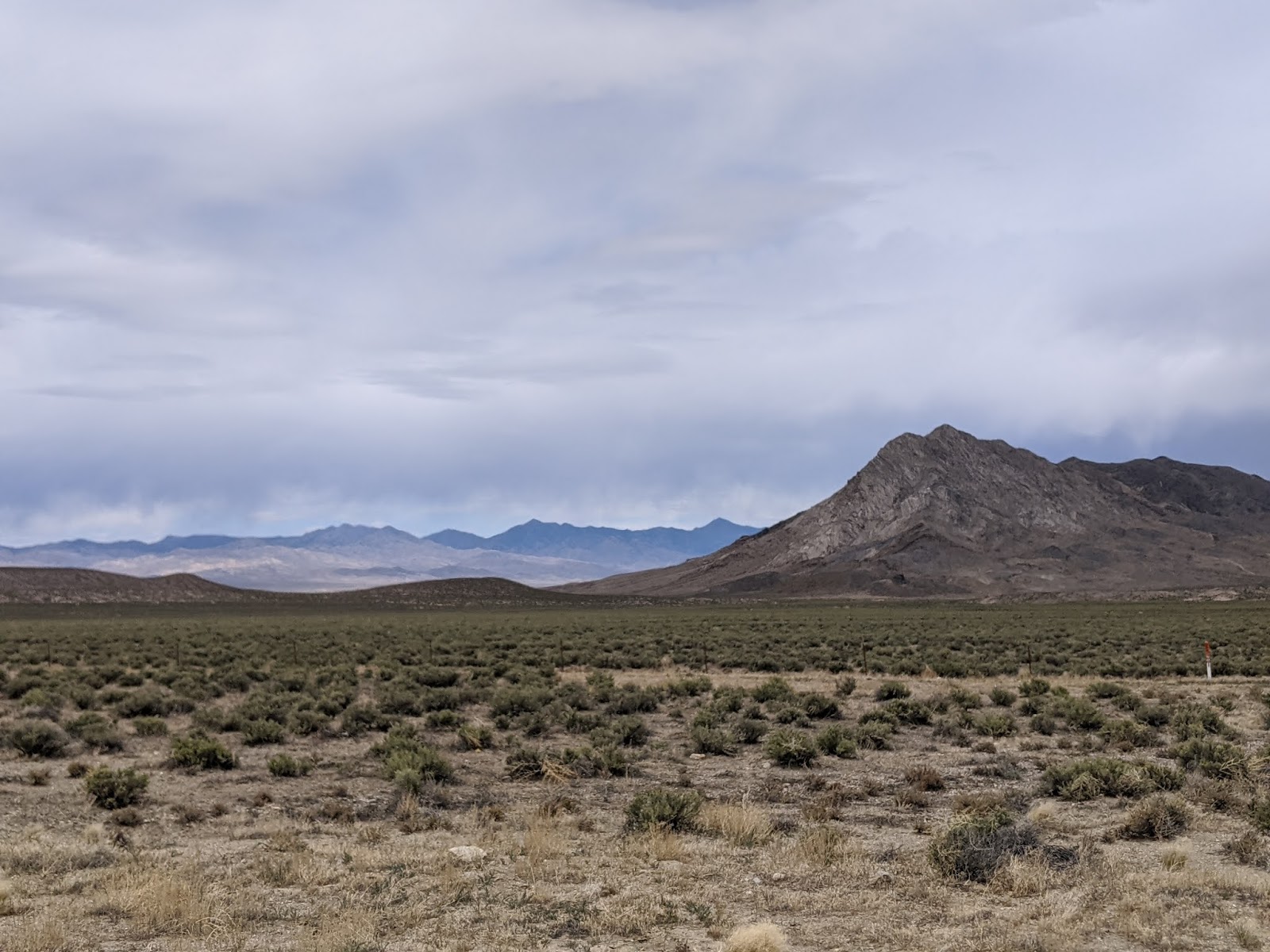
A typical vista on the loneliest road as we drove west:

In the middle of the state was the town of Austin that was settled in 1862. Once the mother of mining camps and a flourishing Old West town, it had 11 buildings listed on the National Register of Historic Places.


The town's Lander County Courthouse has been on the National Register of Historic Places since 2003. Its official stamping station was also closed that Sunday afternoon.


The town's memorial was a place of peace.


Not found in any guidebook we knew but randomly on an online blog was the Middlegate Shoe Tree in the middle of nowhere literally. Who could resist stopping at a tree that first achieved notoriety when a newly married couple were heading home and had their first fight en route near a grove of cottonwood trees? Not us certainly! When the newlyweds stopped, the hot-tempered wife proclaimed she would rather walk home and her husband said, fine, but she could do it barefoot and promptly removed her shoes and tossed them up on the nearest tree.

He then headed to the nearest bar to drown his sorrows only to be persuaded by the bartender to drive back and try and make up with his bride. He did, luckily, and they lived happily ever after if you believe traditional fairy tales! Apparently, the couple returned every year on their anniversary to throw a pair of shoes on the same tree as a declaration of their undying love for each other. I read that travelers passing by the tree have subsequently added their own shoes to the tree which now has thousands of pairs!

As I mentioned in the previous post, we learned on this trip that Nevada was our country's most mountainous state, a fact that surprised us so much, but was borne out as we drove across the state and climbed mountain pass after mountain pass. Steven and I kept oohing and aahing as we gazed at the different mountain formations as we headed toward the town of Fallon near the westernmost part of the state on the loneliest road, aka Highway 50.


Salt flats greeted us near the town of Fallon in western Nevada.


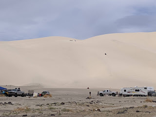


East of Fallon, Highway 50 paralleled the old Pony Express route for several miles. About twenty miles east of town was a mile-long road that led us to Sand Mountain Recreation Area and the Sand Springs Pony Express Station. We were excited to see Sand Mountain as it was one of the few 'singing mountains' in the country and we'd been lucky enough to experience singing dunes outside of Doha, Qatar, several years ago. The singing mountain referred to the low moaning sound the grains of sand made as they shifted.


As it was a weekend, the parking lot was jam packed with RVs and toy trailers to haul dune buggies. I persuaded Steven to stop so we could watch people having a blast roaring up and down the dunes in their buggies. We didn't realize the sand on the dirt road was quite so soft until he tried to turn around and got stuck in the deep sand. We tried digging out from under the tires but to no avail. Luckily, a couple of young, brawny guys saw our little putt putt was in trouble and bailed us out.

Based on the Trump banners and the plethora of large American flags on many of the rigs, we were clearly in Republican territory at Sand Mountain.


It was neat watching a dad and his young son ride up and down the road on their dirt bikes.

I have no idea about the costs inherent in riding dune buggies but I can't imagine they're cheap, especially for children as young as this one.

Steven was clearly more impatient than I wanting to leave Sand Mountain but I was able to persuade him to stay just a few minutes longer, albeit more than one or twice, as I could hardly take my eyes off the guys careening up and down the dunes. I would have given my eye teeth right then to don a helmet and hop in a dune buggy if anyone would have asked or I could have paid!


Sadly, no one asked and there were no options to pay for a ride on a dune buggy - what a bummer! We didn't see anyone else there watching the activities when we were there. I guess people only go to Sand Mountain to participate, not to look.

Next post: Our last stops on the loneliest road in Nevada were the Grimes Point Petroglyphs and Dayton State Park, later the same day.
Posted on August 18th, 2020, from Columbus, Ohio, where we arrived today from Indianapolis so we could visit some of our country's state capitals as we take a very roundabout route to ta state park on the Florida panhandle. Please make sure to take care of yourself and your family in these very challenging times.
Thanks for sharing this.There's always new things to be discovered. Keep on truckin!
ReplyDeleteJohn,
DeleteWe were amazed by the breadth of things to be discovered in small town Nevada as we drove across the Loneliest Road. I would recommend the drive to everyone who has the time and curiosity to head through the Wild West.
The wild wild west ....would have loved to see you and Steven in a dune buggy :)
ReplyDeleteI would have loved to have obliged you, Lina, being in a dune buggy but I don't think that would have been Steven's style!
Delete