After Steven and I toured the amazing murals in downtown The Dalles, we headed west along the Oregon side of the Columbia River Gorge toward the Deschutes State Recreation Area. The steep cliffs towering over the gorge were pretty spectacular!
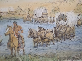
As I mentioned in previous posts, early Oregon Trail emigrants were forced to float down the Columbia River or take a hazardous route around Mt. Hood to head to their promised land of the Willamette Valley. By the1840s, though travelers had established a new, shorter route across the Columbia Plateau, they found it "very dusty" and had to travel long distances "without water or wood."
I cannot begin to imagine what the emigrants felt once they neared their journey's end as they had spent so much time together on their arduous trip out West and now would part company to become settlers. Their relief must have been tinged with sadness.
The Deschutes River drains the eastern slopes of the Cascade Range and flows from Central Oregon to the Columbia River. Near its confluence with the Columbia River, the Deschutes flows through a chasm that emigrant Riley Root in 1848 compared to "the valley of Sinbad the sailor." After a perilous river crossing, they had to ascend a hill which was described as "almost insurmountable" to camp at the summit.
Almost immediately we saw a deer, far more exciting than a lizard!
On the far side of the river I imagined we could still spot the wagon ruts from those who had passed by so long ago on the Oregon Trail.
The thistles bordering the trail were attractive to look at but important to stay clear of!
We noticed the river proved to be the perfect location for water sports with both speedboats and rafts present.
We didn't know what this structure was; it looked like an outhouse or a bird blind but we saw no signage for either.
I guess I spoke too soon about the easy hike because right after that, the hike moved away from the river and headed inland at a fairly steep incline as we began the back portion of the hike! The return hike was called the River View Trail for reasons that soon became obvious.
The views looking back from where we'd come were nothing short of beautiful.
I don't know about you but I have always loved the sounds of trains chugging along. When we first moved into our house in the Littleton suburbs 30 plus years ago, we could regularly hear the trains huffing and puffing along Santa Fe. Nowadays, that's a very rare occurrence because the area between us and the tracks has been so built up.
For some reason, Steven and I blithely ignored the Caution: Bridge Out sign only to pay the piper later!
After hiking a good bit after seeing (and ignoring!) the sign, we reached the spot where the footbridge had fallen down so it meant our very carefully moving among and around rocks, and across the dry creek and then up the other side of the hill. All would have been fine except I grasped some plant to hold onto for support while crossing the creek, only to realize that it caused my hand to go numb and tingly for the next four days!
"Safe and sound" on the other side!
Even though we both wore masks or had them ready to pull up on a moment's notice, we only saw a few other people the entire time we hiked.
I'm not short but even I couldn't touch the ground with my feet. I figured some giant must have planned and built that bench!
With an annual average precipitation of just eleven inches, extreme summer temperatures and strong, drying winds, conditions make it intolerable for most types of vegetation. The plants by the river had looked so lush but here on the hillside, it was like we had stepped into an altogether different world.
We chose a spot overlooking the river for a quick picnic lunch as the weather had turned pretty nasty all of a sudden. What a shame as our hike had definitely surpassed all our expectations and had been delightful.
We had a hotel reservation on the outskirts of Spokane in eastern Washington for the next few nights but, as there was no need to rush, we stopped at the Umatilla National Wildlife Refuge en route. A particular favorite of hunters, the 25,000-acre-sized refuge straddled both Oregon and Washington states.
It was wonderful seeing miles and miles of orchards and signs directing tourists to the many wineries. IF we'd had more time, stopping at one or two would've been fun but not at that late hour.
Before WW II, Richland was just a ranching community of 200 people. Then the government chose the vast sage plains north of Richland as one of the developmental sites for the Manhattan Project, a top-secret nuclear weapons project which lured thousands of scientists and workers. When the war ended, many of them stayed in the planned community. After reading that free tours were given at the B Reactor National Historic Landmark, the nuclear reactor that produced plutonium for the atomic bomb that was dropped on Nagasaki in Japan, we drove thirty minutes out of our way to get there. We'd realized that we wouldn't be able to take the half-day tour but certainly thought we'd see more of Atomic City than the outside only of this building that looked like any strip mall across America!
Though it'd certainly been another long day for us, it was perfect from beginning with the murals in The Dalles, followed by hiking along and above the Deschutes River, driving to and through a chunk of the wildlife refuge, and then the Tri-Cities before finally reaching Spokane. We looked forward to some relaxing days ahead and especially visiting our friends from Littleton who had relocated to Coeur D'Alene just over the border in Idaho several years ago.


No comments:
Post a Comment