Earlier that July day, Steven and I spent several hours mostly exploring the phenomenal travertine terraces at Mammoth Hot Springs near the northern entrance to Yellowstone National Park. Then, after meandering down the park's road toward Norris via Obsidian Cliff and Roaring Mountain, we headed east toward the Grand Canyon of the Yellowstone located approximately in the center of the park.
To get a sense of the magnitude of this 'Grand Canyon,' here's some scientific background. About 640,000 years ago, a huge volcanic eruption occurred in the park, emptying a large underground chamber of partially molten rock or magma with volcanic ash spreading for thousands of miles. As the roof of the chamber slowly collapsed, a giant caldera was formed 30 miles across, 45 miles long. The caldera began to fill with lava and sediments. Infilling of lava flows continued for thousands of years. Scientists believe the oldest Grand Canyon of the Yellowstone formed in rock and sediments from 160,000 to 140,000 years ago. It wasn't as deep, wide, or long as the canyon we all see now. The Yellowstone River eroded weakened rocks to deepen and widen the canyon, a process that is still occurring.
Can you spot the double rainbows? We were pretty excited about seeing them as it had been a long time since our last ones!
We'd hoped to hike down Uncle Tom's Trail, a metal staircase that would take us about 500 feet below the canyon rim to an amazing view of the Lower Falls but the trail was closed, unfortunately. The trail was named after H. F. Richardson, known as Uncle Tom by his contemporaries, who had engineered a trail and pioneered a guiding service in 1898 to lead Yellowstone visitors into the canyon.
It was fun reading that Uncle Tom Richardson used to row his guests across the river in calm upstream waters, then lead them through the woods to the canyon rim, and then down his trail of wooden ladders and rope handrails to the mists of the Lower Falls. Finally, after a steep ascent, Uncle Tom served his guests a campfire supper before rowing them back across the river. How adventurous the park's early visitors must have been to participate in such an outing!
Another overlook with a magnificent, full-on view of the falls:
We could spot hikers across the canyon from us on the North Rim of the canyon.
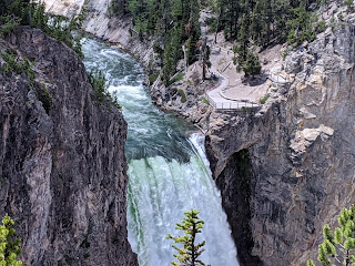
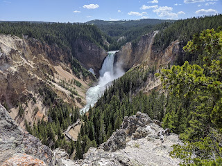
It was easy to see why Artists' Point had come by its name and has also become one of the most photographed views in Yellowstone. Framed by the canyon walls with forests for a backdrop, the Yellowstone River thundered 308 feet over Lower Falls.
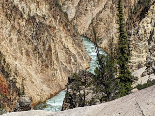
On his first view of the Grand Canyon of the Yellowstone River, 19th-century painter Thomas Moran declared Artists' Point to be "Beyond the Reach of Human Art." That seemed to be an accurate description as words like sublime and breathtaking failed to do justice to the breadth of colors in the canyon. If you're interested in the science of the canyon, the canyon walls were comprised of rhyolitic lava and tuff which had been altered by hydrothermal action. The heat, fractures, and hydrothermal fluids had softened the rhyolite so that, over centuries, the landscape had eroded into fantastic hoodoos, inspiring both artists and visitors!
You can get a sense of the South Rim trail here. Though paved, it was very steep in spots which I wasn't wild about as we headed back uphill to the car as we'd already walked/hiked a good 15,000 steps that day and ended up with another 4,000 steps.
The buffalo was dusty from switching its tail near the trail!
Once back on the North Rim Drive, we stopped at the aptly named Lookout Point for an idyllic view of the Lower Falls. The 308-foot Lower Falls may have formed because the river flows over volcanic rock more resistant to erosion than the downstream rocks, which were hydrothermally altered.
On our way back to our hotel way up in Gardiner, Montana, we stopped to admire Bunsen Peak which was named for German chemist Robert Bunsen. He studied geysers and invented the bunsen burner we all used in high school! Someday it might be fun to hike up to the peak's 1,300-foot summit for some glorious panoramic views of Swan Lake Flat and the Yellowstone River Vally.
Next post: We didn't want to bid adieu to Yellowstone without a stop at West Thumb Geyser Basin en route to Grand Teton National Park!
Posted on December 4th, 2020, from a gloriously warm and sunny day west of Denver. I hope that you and your loved ones are safe and connected as the numbers of coronavirus cases are spiraling upward.


God's own, and our, beautiful world! Thanks Annie for the continuing tour!
ReplyDeleteBeautifully expressed, Andrew. Thanks for reading.
ReplyDeleteLove you ❤️