From the West Virginia town of Beckley located in the center of the southern part of the state, we drove north to the Canyon Rim Visitor Center, part of the New River Gorge National River. It was established in 1978 to protect 55 miles of the New River, encompassing over 70,000 acres between Fayetteville and Hinton, two towns in West Virginia. The river was one of over 400 parks managed by the National Park Service. The 53-mile stretch of the river became part of the Park System in 1978 when it was set aside "for its outstanding scenery, history, geology, hydrology, recreational opportunities, and immense biological diversity."
We walked down 178 steps - not that we were counting of course! - to the bottom viewing platform. Fortunately, we were still fit enough not to need to stop at a bench at the halfway point.

The view from the halfway point:


The completion of the bridge is remembered the third Saturday of October every year when lots of activities are offered on Bridge Day which draws thousands of people to West Virginia's largest festival.

When we'd just driven across the bridge, we had no sense of the bridge's beauty or history.


Contrary to its name, the river was not new but was in fact one of the oldest rivers in the world, and even older than the Appalachian Mountains themselves.

In June of 1974, the first steel was positioned over the gorge by trolleys running on 3" diameter cables that were strung 3,500 feet between two matching towers. It was designed using Corten steel with a rust-like color so that it would never need painting.

The New River Gorge Bridge was placed on the National Register of Historic Places in 2013. The bridge was so tall that two Statues of Liberty and one Washington Monument could fit under the arch with 20 feet still to spare!

I didn't realize that the gorge was at the core of the Appalachian Mountain range, nor that it was one of the largest expanses of relatively unbroken forests in the entire world. With its varied topography and a river corridor running south to north, that meant the New River was the most botanically diverse river system in the central and southern mountains. There were over 1,300 species of plants, including 100 different types of trees, and 10 bat species, 3 of whom roosted in the forest instead of caves.


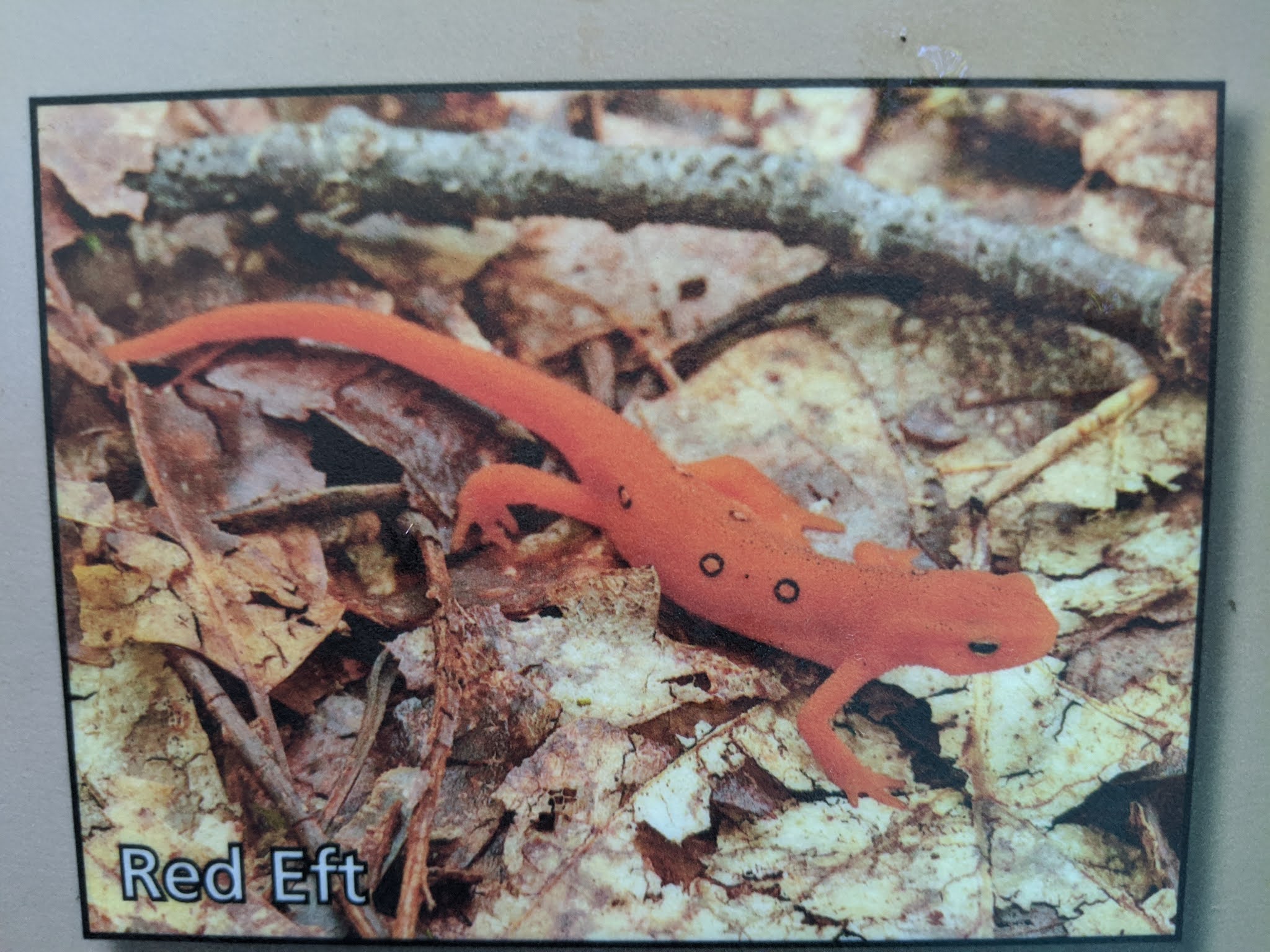
For some reason, West Virginia had one of the most diverse populations worldwide of salamander species with 34! The healthy ecosystem in the New River contributed to the population which included the Red Eft.

Steven and I thought it would be neat to see the bottom of the gorge so we embarked on the Fayette Station Road Tour, a 100-year-old road of hairpin turns.


More than forty coal mining towns sprang up along the banks of the New River in 1873 when the Chesapeake and Ohio Railway created the railroad through the region to take advantage of the coal deposits and lumber shipments to industrial and shipbuilding centers. Life in the towns bustled for over 60 years and the coal industry was strong through WW II. But with rapidly changing mining technology, alternative fuel options, and transportation patterns, the decline came quickly and the mining towns were abandoned by the 1960s.

With the opening of the new bridge, local communities could access work, stores, schools, and families across the river in just moments compared to the harrowing 45-minute drive from before.


From coal mining to rock climbing: The same geographical process that produced the region's coal seams also resulted in a layer of sandstone perfectly suited for rock climbing. These hard, and, in climbers' terms, 'reliable' sandstone cliffs measured 80-150 feet high and were regarded as some of the finest rock-climbing in the US. There were over 2,000 named climbing routes in the park and even more in areas just outside the park - truly a rock climbers' paradise!


At the bottom of the gorge, the road ran parallel to the old train tracks.

At the bottom of the gorge, we crossed over the river via the narrow Tunney Hunsaker Bridge.


Did we ever feel puny seeing the bridge's enormous span from the bridge!

The Fayette Station rapids were probably a great spot for whitewater rafting, too!


One of many waterfalls along the one-way road:

Crossing underneath, we could hear the almost constant rumble of trucks roaring by overhead.

The bridge was the longest steel arch span in the Western Hemisphere and the third-highest bridge in the country.

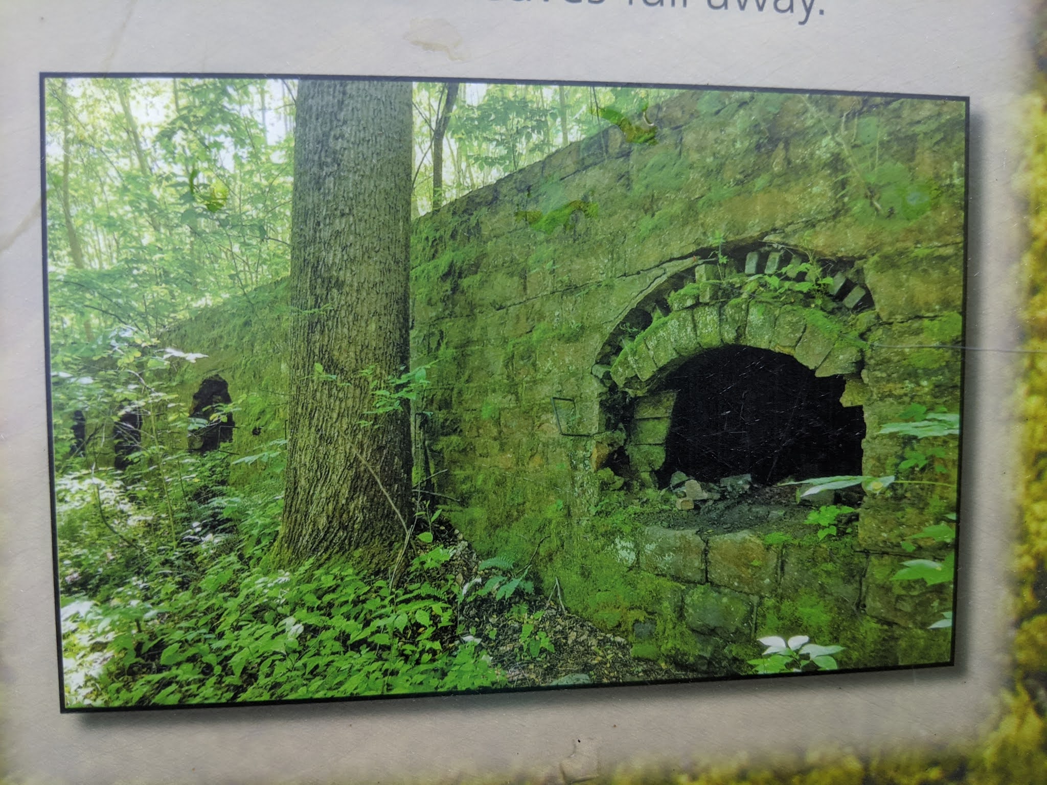
Like all natural environments, the gorge has rapidly changed. The biggest change occurred in the late 1880s when logging, mining, and the railroad combined to play an important role in the country's industrialization. When the industrial activities largely ceased by the 1960s, nature slowly began to conceal the evidence of human exploitation in the New River gorge. Congress, with the support of local communities, established the New River Gorge National River in 1978 to protect the natural and cultural history of the area for current and future generations.

In the gorge's moist climate, vegetation has grown so quickly that abandoned mine sites and coke ovens only become visible during the winter when leaves have fallen.
Steven and I were glad we'd spent the extra time driving to the bottom of the gorge and then back up the other side as the views of the bridge had been spectacular from the bottom.


We continued driving next via the Midland Trail Road to Ansted, a town that had originally been settled by Baptists in 1790 when it was named New Haven. It was renamed to honor a British scientist who had interested English investors in coal-mining operations. Just outside of town was Hawks Nest State Park, named after a sweeping lookout point above the New River. These park's structures had been built by the CCC crews.


These forests were so incredibly lush and thick, unlike so many of our forests here in Colorado that have been devasted by the invasion of mountain pine beetles.

The construction of the three-mile-long Hawk's Nest Tunnel to divert waters from the New River for hydroelectric power resulted in the state's worst industrial disaster. Silica rock dust resulted in the admitted deaths of 100, mostly Black, underground workers of 3,000. A congressional hearing, however, placed the toll at 476 men. The tragedy highlighted the recognition of acute silicosis as an occupational lung disease and legislation was passed to compensate workers.

Beneath the state lodge overlooking the river, the New River formed peaceful Hawks Nest Lake. Above the lake, the narrow canyon and rushing water created one of the most challenging whitewater boating waterways in the nation. We could have taken the gondola down but that wouldn't have been nearly as challenging!

The walkway to the gorge view was a very impressive feat of workmanship, with its 100 steps down to Lovers' Leap Trail. The trail was named after being the scene of a tragic suicide between an Indigenous brave and maiden who had fallen in love but were forbidden to marry.

Graffiti etched into the rocks indicated this had been a popular spot even back in 1879!


I joked with Steven that the handrail must have also have been as old as the graffiti as it was very rickety and not very safe!

Virtually all the political signs we saw in the state supported the Republican governor, Jim Justice, and his ally in the White House.

A short drive then took us to the Gauley National Recreation Area, the largest in the state. We stopped at Long Point for stunning views of Summersville Lake and Reservoir that had been created by a dam.

The Gauley River located below the Summersville dam has been declared one of the world's best whitewater runs as it included over 100 rapids in the 25 miles of river.


The Summersville Reservoir was dedicated by President Lyndon Johnson in 1966.


Next post: A stop at Carnifex Battlefield State Park en route to the state capital of Charleston.
Posted on March 3rd, 2021, as early spring is upon us for an entire week here in Denver. How lucky we are to be once again relishing the low 60-degree sun-filled days. I hope you and your loved ones are safe and healthy, and will also be getting the vaccine soon.
I am telling you...you are the Rick Steeves of America-great shots and good work and safe travels
ReplyDeleteChris P
You are definitely a boon to my spirits! Glad you liked the shots, Chris.
ReplyDeleteXOXO