
After a full day exploring a cheese dairy in Stein, and then the town of Appenzell including its folk art museum, followed by returning our rental car to Zurich, and hightailing it by train to Interlaken, Steven and I had arrived too late at Walter's Hostel to take advantage of the communal kitchen facilities. Unlike many hostels we had stayed at when we first began traveling internationally, there were several other adult couples and no dorm rooms that we saw at Walter's. Prices were so obscene in Switzerland, we just couldn't justify spending well north of $100 a night for some shuteye so Walter's it was for three nights!
The town of Interlaken was our gateway for several nights while we explored the Berner Oberland, the mountainous part of the canton of Bern. We didn't actually spend any time until our last morning in Interlaken, the original mountain resort once 19th-century Romantics redefined mountains as something other than cold and bothersome obstacles.
I hope these maps give you a sense of the region.
Luckily Steven and I had no problem getting train tickets on the spot for the quick jaunt on the narrow gauge railway to Lauterbrunnen. I snagged a window seat to get some shots of the river that paralleled the train tracks.
The community of Zweilutschinen:
It was much easier taking pictures from the slow-moving train than the previous couple of days when we had rented a car and drove through a small part of eastern Switzerland.
It was almost impossible to see much of little Lauterbrunnen in the Jungfrau region as clouds engulfed the mountains overlooking the town.
I knew a so-called postal bus would be awaiting the train's arrival in Lauterbrunnen to take passengers onward to the Schilthornbahn cable car station where we planned to go hiking. I envisioned a cute little bus driven by a postal carrier with bags of mail in the trunk. That may have been the reality decades ago but now it was just a regular bus.
The billboard advertising a very old Bond film with George Lazenby playing the title character greeted us at the very small cable car station!
To begin our hike back to Lauterbrunnen, we crossed over the Weisse Lutschine, one of the rivers in the Berner Oberland.
After a spectacular attempt to measure the Murrenbach Waterfalls from the roof of a cable car in 2009, it was discovered the falls weren't a cascade but a freestanding waterfall and measured 417 meters which made it the highest in Switzerland.
We've done a fair share of hiking in many countries but had never come across a picnic spot like this one before, complete with a BBQ pit and wood also provided.
With no homes nearby, we wondered why there was such a huge woodpile along the trail.
It was a little drizzly but I didn't find it as cold as Steven obviously did. For that, I had my friend Suellen to thank as she had thoughtfully knitted me a cowl for this trip and it kept me warm and cozy.
The Chinese lantern plant provided some beautiful fall colors.
When it rains in this part of Switzerland I read that locals joke it's just washing the mountains! We were hopeful that even though the clouds had rolled in, they might roll out soon.
We detoured through a cabin and RV park to reach Trummelbach Falls, an awe-inspiring spectacle of nature with waterfalls right inside the mountain! Seeing the collection of gnomes made me think of the Travelocity gnomes in one of my favorite TV shows The Amazing Race.
We had a couple of options to reach the falls but it took us no time to realize the elevator was the way to go, at least up!
The Trummelbach Falls drains the mighty Eiger, Monch, and Jungfrau mountains at a rate of 20,000 liters of water per second. It's the only inside-the-mountain, accessible glacier waterfall in Europe. Thank goodness we decided to take the easy way up inside the mountain most of the way as we still had to hike up a lot of stairs.
The great view onto the valley floor from halfway up:
The falls were loud as they roared through the narrow opening in the rocks.
Up to another level with more exciting views:
Seeing the three mountains' melt roar through the mountain at 5,200 gallons a second was hugely impressive of the power of nature.
At the top on level ten, we were able to look down on the level where we had just been. We could certainly understand why no children under four were allowed and why signs cautioned people not to lean over the barriers!
If we'd chosen to walk up, this is how steep the stairway would have been.
We much preferred the view looking out toward the valley!
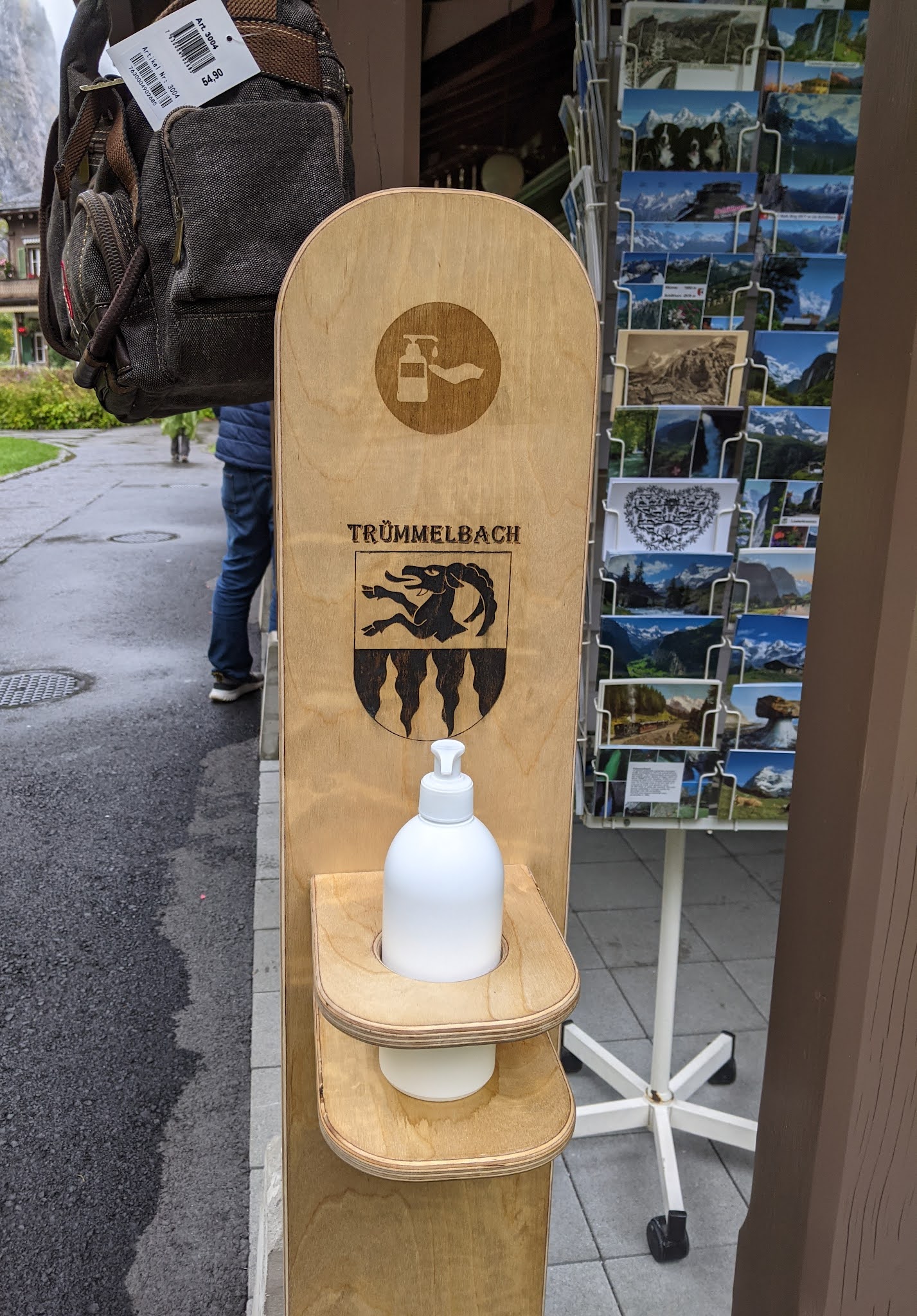
Ever since the pandemic started about 18 months ago, we'd never seen a personalized sanitizer container like this one at Trummelbach.
In Switzerland, hiking 'distances' weren't given in the number of kilometers still to trek but rather a time to reach your desired location. Call me old-fashioned or a stick-in-the-mud but I never did get used to that in all of our hikes in Switzerland because, in my mind at least, people hike at different speeds whereas an actual 'distance' is measurable and the same for all.
It seemed so odd seeing this Arabic-language sign cautioning people not to throw trash in this small river crossing. I wondered why Middle Eastern travelers had been targeted and not the more popular Asian travelers.
You may laugh but having a Toi Toi at regular intervals was handy and certainly prevented the 'fouling' of pristine trails.
Steven was so, so happy being able to hike in the Alps as viewing them had been what he looked forward to the most on our two-plus month trip.
I wish this post could also provide audio as the sound of the cowbells was so melodic and constant on our hike alongside farms.
Imagine a vending machine but instead of selling chips and candy bars, this one sold cheese and other products made on-site with payment all on the honor system! No way could you possibly buy fresher cheese.
Behind the low-lying clouds were Buchenbachfall but the visibility was so poor we couldn't see any falls.
A little further on we saw a sign that said 265-meter-high Spissbachfall was here but again we couldn't see any falls.
In May of 1889, a large landslide occurred by Spissbach after an unusually long and snowy winter and a sudden period of warm and rainy weather. Tens of thousands of cubic meters of debris completely buried several barns and a house
A sign above the flower boxes announced the home had been built in 1912.
Another mini cheese dairy in case hikers were hungry!
Up ahead was yet another waterfall - this was Staubbach Falls, the second-highest in the country at almost 900-feet high. As the falls were said to look like dust or 'staub' the name made sense.
It was too wet and slippery for us to want to hike the trail built into the cliff that takes people behind the falls.
Steven trying to keep dry in front of Anna's Chalet while I was off taking photos of the falls!
A grass-covered roof:
The cemetery and church back in Lauterbrunnen:
Too bad a Toi Toi hadn't been available as this public bathroom in Lauterbrunnen was appallingly dirty and full of cigarette butts and other trash- one of the worst I'd seen anywhere and that's saying something.
We don't come across these distance markers very often in our travels but I always get a kick out of seeing them when we do see them. Too bad the mileage wasn't included - funny that all the countries were also listed in the same direction!
On arrival back in Lauterbrunnen, we walked through town to the cable car station to take the short cable car ride up to Grutschalp. I'd hoped to spot a now-abandoned, 100-year-old funicular train track below us on the ride up but the rain made it tough to see anything much below.
At the tiny community of Grutschalp, we immediately caught the waiting vintage train to Murren so we could hike from there down to Gimmewald that was once one of the poorest places in Switzerland before modern tourism helped put the tiny community on the map.
Even though the low-lying clouds obscured most of our views, we sure didn't complain about the incredibly scenic cliffside views en route to Murren.
Murren was twice the height of Lauterbrunnen but we had no problem with the altitude as we're so used to our home city of Denver being called the Mile High City, i.e. 5,280 ft. above sea level.
These images on our arrival in Murren made us both smile!
I just loved somebody's sense of humor who came up with the small writing and picture on the top right of the sign indicating the time it takes to reach Gimmewald - 35 minutes to walk and 15 minutes on a sled as it's all downhill!
We knew from seeing several falls earlier that day that the German word 'bach' meant falls!
In the States we see electric fences to keep dogs in a certain space. Switzerland had the same but for cattle!
I still couldn't get used to having gondolas go so closely overhead above cattle but the cows didn't seem the least bit fazed by the sound and sense of motion just above them.
Steven was in his happy place with the blue sky just making an appearance and hiking in the Swiss Alps! Back in the mid-70s, I'd lived for a year in Geneva in the French-speaking part of the country but I had spent very little time in the Alps so we were both like kids with smiles plastered to our faces the entire time with these majestic views!
What a day with even Mother Nature cooperating so we got a few glimpses of the snow-capped mountaintops!
As stunning as the views were, we were reminded that life isn't always as idyllic as it looks in the mountains and that nature's wrath in the form of avalanches can wreak untold damage in an instant. That was why snow bridges were the most common permanent avalanche barriers. A sign informed us that snow bridge barriers are assembled in the valley with the foundations and mounting done on-site in the mountains often with helicopter assistance required.
Another barrier in the starting areas of avalanches were three-leg mountings called Ogi-Bocke that are placed where young trees can also be planted, i.e. up to 1,800-2,000 meters above sea level. After about 20-30 years, the trees take over the function of the barriers as the three-leg mountings rot.
Thinking it was going to be darned chilly, we wore all of our layers but I had begun shedding a couple of them a while earlier as the sun had finally made an appearance.
Welcome to Gimmewald!
I was glad to take a break for a few minutes and watch these goats pretend fight!
I'm sure moneymaking opportunities in these tiny, tiny communities are few and far between so I was glad to pop into one woman's home who had a 'misch masch' of handicrafts available for sale.
She was an incredibly talented crafter with lovely knitted, embroidered, sewn, and crocheted items. There was nothing I needed and space was at a premium in our duffel bags but I still felt I 'needed' to buy a small token when she popped into the alcove where she displayed her talents.
As the mountain pastures are used to grow hay, small barns were built closer to the hay.
The photograph indicated which mountain was which on a clear day but we couldn't tell as the clouds still played hide and seek with the mountains!
Depending on one's point of view, the village of Gimmewald was 'saved' from developers because of its avalanche zone classification. It only was home to about 120 residents, down from 300 years ago. They make their living by raising hay but one family can only harvest enough to feed 15 cows. Residents receive subsidies from the government to live in Gimmewald.
Another type of unique store in Switzerland!
Though looking more like an alpine art gallery, this was a cheese hut where cheese is produced.
Lina: Seeing these chickens made me think immediately of our dear Chris. I texted this photo to Mike letting him know that Chris was on my mind.
A new thing to us was this Honesty Shop which featured local handicrafts and edibles with no staff. I bought something and just left money as directed. What a great concept but I wonder how viable it might be elsewhere.
Because the hut was used to store cheese, it was set on stilts.
The largest building in town was the former schoolhouse which gave us a clue that this was a Catholic Swiss town. If it had been a Protestant Swiss town, the largest building would have been a church. Schoolchildren now attend school down in the valley at Lauterbrunnen which was quite a commute! The former school was now used for monthly visits from a Protestant chaplain.
The alpine 'street sign' was like a very mini Times Square showing the location, the altitude, the time it takes to hike to nearby spots, and, critically for us, which ones are marked in red and white for more serious hikers than we are!
Several of the buildings in Gimmelwald were built as duplexes divided straight down the middle to house two families. If you click on the photo to make it bigger, you can spot some writing on the top level. The country blessing translates to: "Summer brings green, winter brings snow. The sun greets the day, the stars greet the night, This house will protect you from rain, cold, and wind. May God give his blessings."
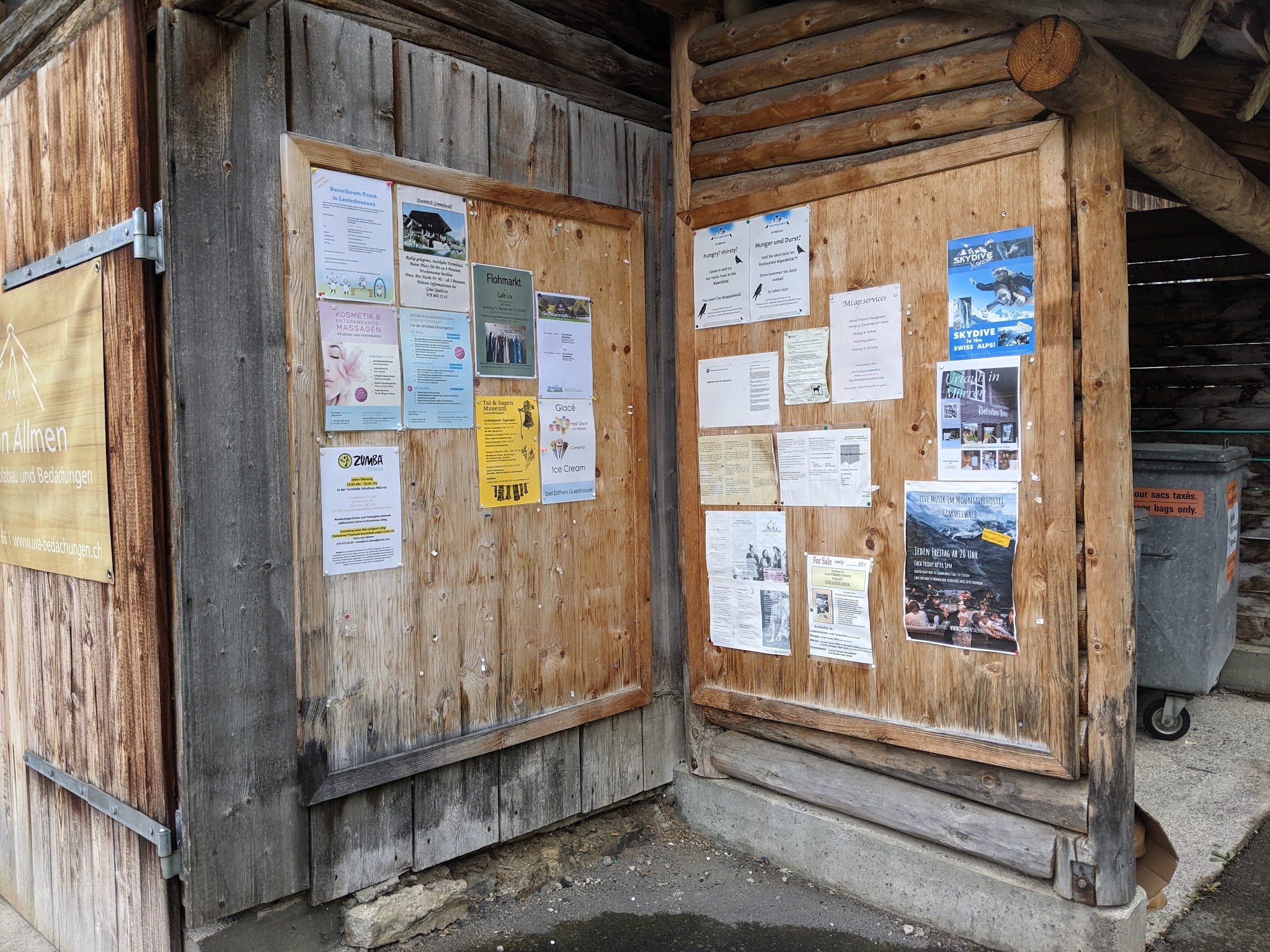
The announcement board had information on one side for local news and the other of interest for tourists.
We admired the huge collection of cowbells on the side of another home. I don't know how much they were for looks versus use, however. I read that Swiss cows actually have legal rights and that, even in the winter, they must be taken out for exercise three times a week!
Do you recall from a previous post about Zurich having a zillion water fountains? Well, little Gimmewald had its own 'water fountain' or trough, more to the point! This was the location of the village's historic water supply, popular for both cows to take a drink and village kids to bathe in.
The oldest building in the village was the log-cabin-style Husmattli built in 1658. Many of the older homes were constructed without nails with the wood logged in and milled in the Sefinen Valley below.
Did you get the sense yet that gnomes are way popular in Switzerland?!
Gimmelwald residents heat with wood that needs to age a couple of years to burn better but, as part of a green energy policy, Swiss building codes now require that thirty percent of new structures must provide their own power. The solar panels on this roof heat up water for bathing and home heating and the furnace is only used from November to February.
In use as a schoolhouse from 1810 until 1930 was Alpenrose before being converted to a family home. Under the eaves were more big ceremonial cowbells that swing from cows' necks during the procession up to the high Alps.
The Gimmelwald Fire Station is especially critical during the Fohn season, a period of fierce dry winds when there is a 24-hour fire watch.
Below scenic Gimmelwald was the Selfinen Valley.
After a perfectly delightful stroll in the postcard-pretty village, we walked to the cable-car station which arrived in the 1960s. We just had a few minutes to wait before taking the cable car through more spectacular views to Stechelberg.
Far below us was the procession of cows making their way from the alpine pastures to their winter homes that we had read about in the folk art museums in Stein and Appenzell.
After a long but exciting first day in the Alps, we were back 'home' in Interlaken.
It was so dark when we had walked up from the train station the night before to the hostel to see this fun roundabout!
Next post: Riding the rails for more hiking in the Alps!
Posted on November 2, 2021, from the Tuscan hill town of Montepulciano.


Switzerland offers gorgeous scenery and brilliant skiing .. we were lucky enough to ski Zermatt, Wengen, Murren and Grindewald. And while Canada also has fabulous skiing in the Rockies, Swiss skiing weather is far kinder. You must return to the Alps with your skis ! xo
ReplyDeleteLucky you skiing in the Swiss Alps but my downhill skiing days are long over!
ReplyDeleteXOXO
Amused by the "Toi Toi". What a wonderful day you had. You really packed in a lot of wonderful vistas!! Janina
ReplyDeleteUs pack a lot in in one day - surely you jest, Janina! Definite highlights for me were the Trummelbach Falls and the hike down into Gimmelwald from Murren. Thanks for reading and commenting.
ReplyDeleteBeautiful, pastoral, bucolic, almost too perfect.
ReplyDeleteAlmost too perfect would be how I'd agree our hike was the next day, Paul, from Mannlichen to Kleine Scheidegg. I thought this first hike had a great mix of elements.
ReplyDelete