Earlier in the day, Steven and I had driven from Bend in central Oregon along the incredibly scenic Cascades Lakes Byway to take in some of the Cascades Range's mountains and many lakes. The Byway passed through a volcanic and glacial landscape of great diversity and tremendous significance. There were such diverse geographical formations as shield volcanoes, cinder cones, sheets of pumice and ash flow.

We knew from just having come from Lassen Volcanic National Park in Northern California that volcanoes build up the land while glaciers tear the land down. During the last Ice Age, glaciers flowed far down both sides of the Cascades and cut deeply into volcanic cones, carving out glacial valleys. Eruptions took place under glaciers and often melted holes in the ice. That activity is what created the more than one hundred small and large lakes behind lava dams, in volcanic craters, etc.
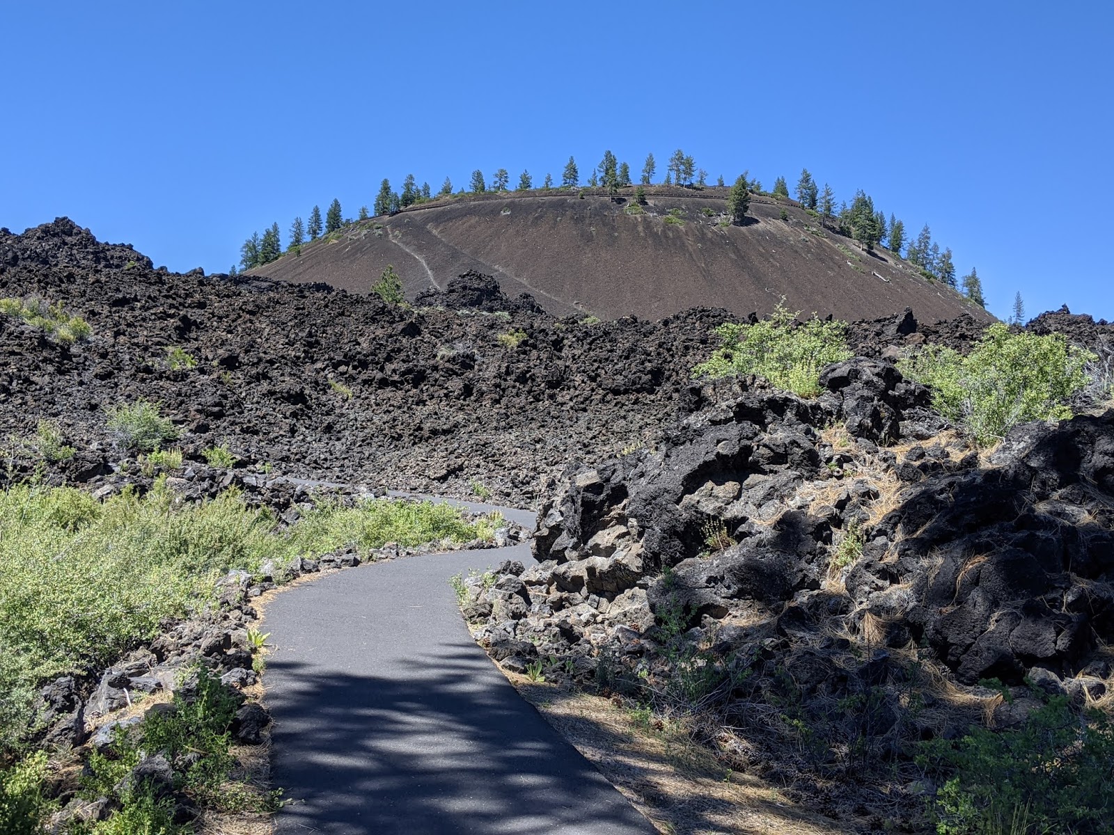
To get an immediate sense of the area's rich volcanic history, we headed to Lava Butte in the Deschutes National Forest. Lava Butte was part of a system of small cinder cones on the side of Newberry Volcano.
As the three-plus-long mile road to the top of Lava Butte was closed because of Covid-19, we were perfectly content to hike the far shorter Trail of the Molten Land that would take us across the basalt lava flow to its source at the base of the cinder cone.
Just a few miles from the stunning Cascades Mountains, the
Molten Lands were a world where lava dominated the landscape and living things have had to adapt to a harsh environment. We were looking forward to learning about the many unique features of this lava flow and the survival stories of local high desert plants trying to make a living here.
We tried to imagine standing here 7,000 years ago as a wall of molten lava roared toward us, engulfing the forest in flames. Surprisingly, the flow cooled even though it reached temperatures of over 1,200 degrees. That cooling caused the flow to break into the large chunks of black rock we saw everywhere around us. Because the force of the flow was overtaken by gravity, its path changed, flowing downhill toward the Deschutes River to the west.
In the distance, we caught another view of Mt. Bachelor that we'd first spotted on the Cascades Lakes Byway that morning.
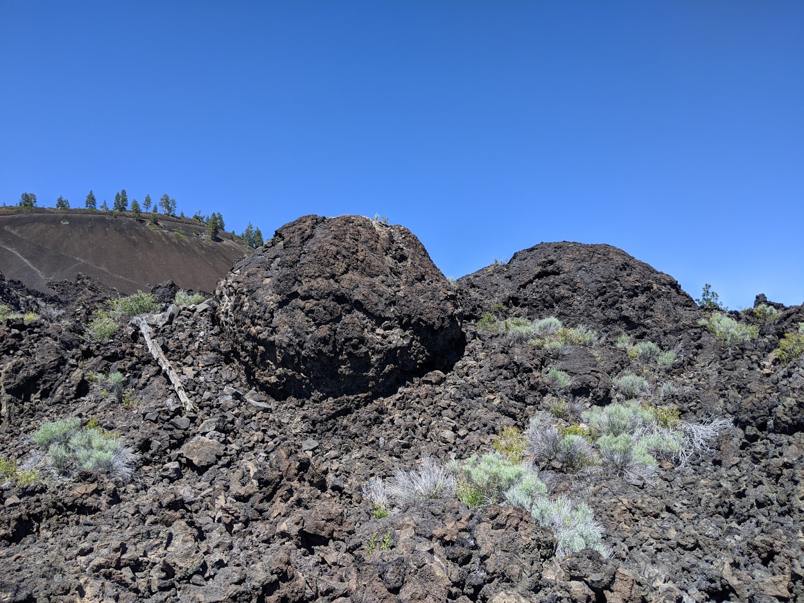
It was hard to grasp that these giant boulders began as just small chunks of molten rock when they broke of the sides of the molten river channel. As they rolled and tumbled through the flow, they grew in size as they moved. It was just like a snowball rolling downhill and growing larger as more snow stuck to it. The trail we were on followed the path these 'lava snowballs' or chunks took all those years ago.

Where we were standing was on the edge of the Newberry Volcano, one of the largest volcanoes in North America. Located between the Cascades to the west and the High Desert Plains to the east, Newberry and its 'apron of volcano' encompassed almost 1,200 square miles, the size of Rhode Island! With its many eruptions from as far back as 400,000 years ago to as recently as 1,300 years ago, the Newberry Volcano has had a significant impact on Oregon and surrounding lands with deposits from its most explosive eruptions as far as Idaho to the northeast and San Francisco Bay to the southwest.
This was the edge of a lava levee, one of the three main gutters that channeled lava as it poured from Lava Butte. The flows buried 10 square miles of pine forests - about equal to almost 5,000 football fields! - and blocked the
Deschutes River in five places.
The plants were called xeric as they have adapted to dry conditions, making them some of the hardiest plants we'd ever encounter. It was remarkable that they have been able to adapt to such an unforgiving world where minimal amounts of soil and water exist!
We were fantastically lucky being at Lava Butte during a very brief period of the summer when the rocks came alive with color. It was almost impossible imagining how these plants have stayed alive with just a few drops of water a day. They've managed by either producing small leaves, growing special small hairs that can catch the morning dew or developing waxy coats that reflect the sunlight.
From this viewpoint, lava spread over eight miles and up to a hundred feet deep in some places. Somehow, scientists have figured out that there was enough basalt left over from the lava to build a four lane highway around the earth six times.
These sunshine yellow flowers that couldn't but help put a smile on our faces were sulfur buckwheat. We were incredibly lucky to be there as they only bloom a few weeks each summer. On top of that, we saw them at their peak before center of the flower clusters turn orange, indicating their brief moment in the sun was done.
The view from Phil Brogan Viewpoint of the volcanic peaks was absolutely striking. Part of the Cascade Range that stretches from California to Canada, they were also part of the much greater number of volcanoes and mountains around the Pacific Ocean known as the Ring of Fire. I hadn't realized that 80% of the world's large earthquakes occur in this seismic region. I read that scientists pay close attention to this area because of the combination of the Ring of Fire and the potential for volcanic eruptions with the hope of warning everyone of potential dangers.
The mountains, from left to right, were the 10,358-ft.-high
South Sister, 9,175-ft-high
Broken Top, 10.047-ft-high
Middle Sister, and finally 10,085-ft-high
North Sister. Earlier that day, while on the Cascades Lakes Byway we were privileged to see the Three Sisters closer up. Between the North and South Sister mountains,
Collier Glacier is one of the largest glaciers in Oregon. As one of a few glaciers that have been intensively studied and monitored for extended periods of time. The glacier once measured nearly two miles long but, due to climate change, it has shrunk to approximately half of its peak size.
Mt. Bachelor came in at 9,068-ft.-high.
We read that scientists believe that though the flow may have begun as a
fluid pahoehoe, it then transitioned into a traditional
a'a flow, burying the landscape under an advancing front. The rock that looks like bent fingers in middle below may support that theory.
As dazzling as the sulfur buckwheat were, the grasses and other plants put on a show in that harsh environment for us, too!
While walking on the paved trail we'd spotted a few twisted trees but were certainly very intrigued with this one dubbed the
Lava Ness Monster by park staff because of its resemblance to the famous
Loch Ness Monster in Scotland! Lava Ness had started out as a pine seed that somehow found its way into these unforgiving lands. Even though the lava cooled over 7,000 years ago, there was still very little soil here because the dry climate had failed to weather the rocks quickly. The plants only survived on a small area of soil by sending out a single moisture-seeking taproot.
At the base of Lava Ness, one root was much larger than the others because just one root reached the water and the other roots just anchored the tree. Although Lava Ness was still standing, the small roots of the other dead trees we'd spotted weren't strong enough to keep them upright.
Near the bottom of the trail, the lava rocks were smaller and grayer.
The wonder of nature - just a ten-minute walk from the end of the trail, were sky high deciduous trees!
Like virtually every visitor center we'd hoped to see this month-long road trip, the park's Lava Lands Visitor Center was also closed because of Covid-19.
I can't imagine with everything else Steven and I still would like to discover here in the US and abroad when we can resume international travel that we will ever likely return to this part of Oregon but,
if we were lucky enough, I'd sure love to hike to the top of Lava Butte.
Next post: The Petersen Rock Gardens outside of Bend were a most unusual roadside attraction that we still talk about now three months later!
Posted on September 20th, 2020, from Raleigh, North Carolina as we take an extended hiatus in the Carolinas from the Florida Panhandle because of Hurricane Sally. As ever, Steven and I continue to hope you and your loved ones stay healthy, safe, and connected during these challenging times.


I too am astonished to see the beautiful blossoms in such an arid and hostile growing environment. Arizona's deserts also produce amazing blooms despite the dry soil and scorching heat. And I loved the photo of the Lava Nest monster, a definite cousin to the Scottish Loch Ness. Happy and safe travels to you and Steven. xo
ReplyDeleteIsn't nature astonishing that something so colorful can bloom amid such arid conditions? I loved seeing Lava Ness monster surrounding the other barren trees, too!
DeleteYou can grow a lot of those plants here in Colorado. Janina
ReplyDeleteDidn't realize that, Janina. If we're ever in Denver long enough during the summers, it would be great to plant them and enjoy watching them grow.
Delete