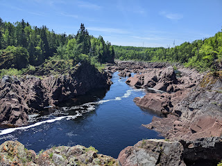
Before leaving Grand Falls-Windsor for our drive toward Twillingate in northeast Newfoundland, we spent some time at the town's Corduroy Brook Nature Center & Trail.
What an unusual regulation!
I hadn't known that instead of feeding ducks bread, more appropriate foods were barley, wild bird seed, frozen corn or peas, and chopped lettuce.
Labrador Tea was the name given to an evergreen shrub that grows up to three feet high in coniferous bogs and forests across the island of Newfoundland and Labrador located across the Strait of Belle Isle and geographically in the province of Quebec. To make the tea, leaves are collected in the spring and stored in an airtight container until they are steeped in boiling water. The leaves themselves cannot be boiled because they release a harmful alkaloid.
Having almost tripped this morning on an uneven path while walking with a friend, I was all in favor of the markings that had been placed indicating possible hazards. But Steven and I thought that park officials had gone to the extreme by marking even the tiniest hazard!
Some heartwarming advice on our way to Scout Pond:
I was drawn to the grove of white birch trees as I grew up on Birch Avenue in Ottawa, Canada eons ago but hadn't realized only the bark of mature trees became creamy white. Birch trees were among the most common and important trees in the province as they were used for fuel wood and for manufacturing plywood and flooring.
Little Corduroy Pond looked far more like a regular pond than the massive Western Brook Pond we'd taken a boat tour on a few days previously.
There was no wonder that a common plant in the nature center was Rhododendron because its pretty pink five-petal flowers were visible everywhere in the park. I hadn't known that their flowers were toxic to people.
It was comical that rather than moving the small rock away from the path, it had been painted red so trail users would know it was 'dangerous.'
Steven and I didn't remember seeing a Low Head Barrier before - it was constructed of logs to create plunge pools immediately downstream. The pools provided well-oxygenated water and valuable protection for young trout during periods of low flow.
Corduroy Brook ran about ten miles until it met with the Exploits River.
Also in Grand Falls-Windsor was Salmonid Interpretation Centre.
We were so lucky to find that the demand of bus groups had caused the centre to open early because it was supposed to have been closed. Fishways were constructed at Grand Falls to allow salmon to travel where none had gone before. After a huge fish hatchery was built, 50 million young salmon or smolts were released over the next ten years throughout the Exploits River.
The watershed of the Exploits River was 1,200 kilometers long and ran through the center of the island. The first recorded harvest of Atlantic salmon on the river took place in 1768.
Atlantic salmon were called the King of Fish.
We learned at the center that smolt entering the Power Canal during the annual smolt migration was directed by a series of floating louvers to the bypass system from the fresh water to the ocean.
A series of 35 pools allowed adult fish to progress through the fishway at their own pace and return to the river above the falls. The fishway provided over 10,000 square kilometers of new habitat for the Atlantic salmon.
The fishway or fish ladders resembled stairs and allowed migrating fish to slowly move from one elevation to another by a series of pools. The number of pools was based on the elevation difference from the base of the obstruction to the area above where they could take advantage of spawning and rearing habitat.
Waterfalls on the left and the hydro dam on the right:
Put it down to the fact we were skeptical Americans but Steven and I were quite frankly shocked to learn that the enormous outlay in public funds to build the fishways was only done to conserve the Atlantic salmon, not for any tourism dollars. How admirable was that!
The 927-foot-long Bishop's Falls Trestle spanning the Exploits River was the longest trestle in Newfoundland. The former railway trestle, longer than the RMS Titanic, was built in 1901.
Bishop's Falls:
Since arriving in Newfoundland a week earlier, we had seen several signs advertising the Come Home 2022 campaign which encouraged former residents of Newfoundland and Labrador who had moved away mostly for economic reasons to 'come home' and remember the wonders in their former backyard.
These prehistoric Beothuk projectile points were 500 years old.
Archaeologists had found evidence that the site had been used as early as 1000 AD by the ancestors of the Beothuks but most of the material was dated from 1650-1720. The information collected was able to provide a picture of the Beothuk's lives prior to the arrival of a large number of European settlers.
A historical document mentioned the presence of Beothuks further east in Gander Bay in the 1700s but no archaeological sites were found until 1981 when much of the coastline of Notre Dame Bay was surveyed.
Once Boyd's Cove was found, it merited a closer look by archaeologists because it was a dry and flat open meadow and therefore perfect for camping. With an open stream nearby, a beach where canoes could land safely, and an annual smelt run nearby, the site would be even more attractive to the Beothuks.
Mounds and eleven shallow depressions in the earth were found that convinced scientists this was a Beothuk site from hundreds of years ago. The Beothuks built their homes by digging shallow pits with wigwams in them and placing the excavated earth around the homes' perimeter. Sailcloth, animal skins, and bark were used to roof the wigwams.
At first, the Beothuks made stone projectile points like their ancestors. Later, they used rhyolite, a volcanic stone that was pretty common in the bay before substituting iron for stone to make arrowheads and harpoon blades as they were more effective than brittle stone.
In lieu of trading with the newly arrived Europeans as most North American indigenous people did, the Beothuks preferred to visit their abandoned fishing stations each fall and collect the precious iron tools and metals that had been left behind.
Caribou were vital to the Beothuks because they provided meat, skin for clothing, wigwam coverings, sinews for sewing, as well as bones for ornaments and tools. The Beothuks built long fences along known caribou routes to force the caribou into the water where the slow and helpless targets were easy prey for Beothuk arrows and lances.
Historical and archaeological sources have determined the Beothuks, like other Indigenous cultures, used red ochre as body paint and as part of their burial rituals. Red ochre, which had been used for about 7,500 years in this part of the world, may have been a link with both life and blood. Grave goods found at other Beothuk sites suggested a belief in the afterlife.
Once Europeans spent the entire year in Newfoundland, the Beothuks were pushed away from their coastal hunting grounds to the island's interior where there was little food to support them. In the late 1700s and early 1800s, many bloody encounters were recorded between settlers and the Beothuks. The last of the Beothuk people died in the provincial capital of St. John's in 1829.
In the center's restroom was this cute sign. I wish it were in ALL public bathrooms!
A short trail led to the archaeological site from the visitor center.
The numbers referred to the different types of wigwams constructed in Boyd's Cove on the shores of Notre Dame Bay
From this second vantage point, it was easier to spot the shallow depressions where the wigwams were located.
Tiny Wilson's Falls:
Boyd's Cove:
The Spirit of the Beothuk was a statue erected to honor the Beothuk who lived all over the island of Newfoundland and may never have exceeded 500-700 people.
The community of Boyd's Cove North and ...
St. George's Anglican Church:
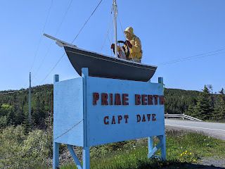
At the gateway to Twillingate, our 'home' for a couple of nights, was Prime Berth, a historic fishing premises ranked as the number six museum in all of Canada. Unfortunately, it was closed.
Since it was still early enough, we began hiking the rugged Bert Stuckless Memorial Trail to Spiller's Cove.
Lezlie: This was where I called you from while Steven hiked on and enjoyed the views of rock formations!
Spillman had constructed the unusual but still accessible trail. Steven and I were both fans of the ropeway to climb back up the steep hill!
The temperature was considerably chillier this far north compared to when we'd started the day in Grand Falls-Windsor. Perhaps the cool weather had dissuaded others from coming out as we had the place to ourselves.
East of Twillingate was the community of Durrel.
Views of gorgeous Twillingate while we waited for a table at Annie's Harbour Restaurant that night:
Do you think Steven liked his seafood dinner at Annie's with Annie?!
Our Floral Dreams Suite at the Hillside B&B was a delightful place to rest our heads for two nights.
Next post: Magnificent views from Long Point Lighthouse and Twillingate Dinner Theater!
Posted on September 18th, 2022, from another sunny and hot, early fall day in Denver before a cold front moves in.


I think any Newfoundlander who read your recent posts would happily "Come Home" to their beloved province where houses are painted in the happiest of colours, where the seafood is plentiful and delicious and where sea vistas await you at every corner. xo Lina ox
ReplyDeleteWhat sweet words, Lina - thank you for being such a faithfulness reader and always taking the time out of your busy schedule to comment. That means so much.
ReplyDelete